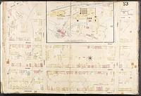
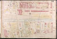
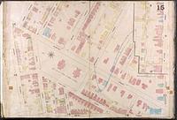
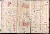
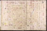
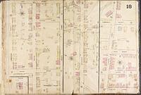
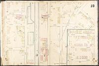
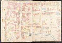
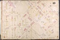
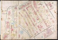
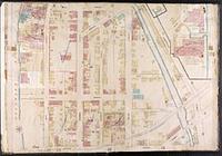
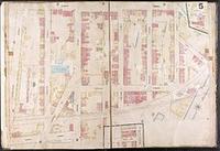
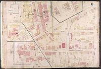
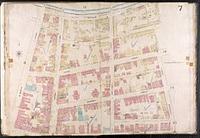
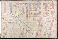
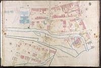
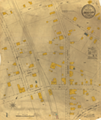
1. 1874 Sanborn Insurance Diagram of Trenton, NJ (Index)
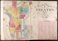
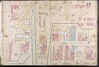
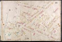
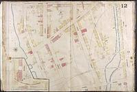
Sanborn Maps were originally created for assessing fire insurance liability and include detailed information about building construction and functi...
Sanborn Maps were originally created for assessing fire insurance liability and include detailed information about building construction and functi...
Sanborn Maps were originally created for assessing fire insurance liability and include detailed information about building construction and functi...
Sanborn Maps were originally created for assessing fire insurance liability and include detailed information about building construction and functi...
Sanborn Maps were originally created for assessing fire insurance liability and include detailed information about building construction and functi...
Sanborn Maps were originally created for assessing fire insurance liability and include detailed information about building construction and functi...
Sanborn Maps were originally created for assessing fire insurance liability and include detailed information about building construction and functi...
Sanborn Maps were originally created for assessing fire insurance liability and include detailed information about building construction and functi...
Sanborn Maps were originally created for assessing fire insurance liability and include detailed information about building construction and functi...
Sanborn Maps were originally created for assessing fire insurance liability and include detailed information about building construction and functi...
Sanborn Maps were originally created for assessing fire insurance liability and include detailed information about building construction and functi...
Sanborn Maps were originally created for assessing fire insurance liability and include detailed information about building construction and functi...
Sanborn Maps were originally created for assessing fire insurance liability and include detailed information about building construction and functi...
Sanborn Maps were originally created for assessing fire insurance liability and include detailed information about building construction and functi...
Sanborn Maps were originally created for assessing fire insurance liability and include detailed information about building construction and functi...
Sanborn Maps were originally created for assessing fire insurance liability and include detailed information about building construction and functi...
Sanborn Maps were originally created for assessing fire insurance liability and include detailed information about building construction and functi...
Sanborn Maps were originally created for assessing fire insurance liability and include detailed information about building construction and functi...
Sanborn Maps were originally created for assessing fire insurance liability and include detailed information about building construction and functi...
Sanborn Maps were originally created for assessing fire insurance liability and include detailed information about building construction and functi...
Sanborn Maps were originally created for assessing fire insurance liability and include detailed information about building construction and functi...
![29N 08E - Survey Map of Sanborn Township, Alpena County [Michigan]](https://geo.btaa.org/rails/active_storage/representations/redirect/eyJfcmFpbHMiOnsibWVzc2FnZSI6IkJBaHBBbE5YIiwiZXhwIjpudWxsLCJwdXIiOiJibG9iX2lkIn19--cfa53a27a0c2edbd73be30e3a2b4f1fb0278943d/eyJfcmFpbHMiOnsibWVzc2FnZSI6IkJBaDdCem9MWm05eWJXRjBTU0lJY0c1bkJqb0dSVlE2RW5KbGMybDZaVjkwYjE5bWFYUmJCMmtCeURBPSIsImV4cCI6bnVsbCwicHVyIjoidmFyaWF0aW9uIn19--63f58a7f811efdee35925b7691d3c2e688741bf3/feb452c5-a24d-4c63-831f-ac59987e7204.png)
1839. Clason, Lewis. A survey map of the Western half of Sanborn Township in Alpena County, Michigan, measured in 1839. Department of Natural Resources.
![29N 09E - Survey Map of Sanborn Township, Alpena County, Page 1 [Michigan]](https://geo.btaa.org/rails/active_storage/representations/redirect/eyJfcmFpbHMiOnsibWVzc2FnZSI6IkJBaHBBbFZYIiwiZXhwIjpudWxsLCJwdXIiOiJibG9iX2lkIn19--c79b650ff97459ed2703173926c9e2d2ea233310/eyJfcmFpbHMiOnsibWVzc2FnZSI6IkJBaDdCem9MWm05eWJXRjBTU0lJY0c1bkJqb0dSVlE2RW5KbGMybDZaVjkwYjE5bWFYUmJCMmtCeURBPSIsImV4cCI6bnVsbCwicHVyIjoidmFyaWF0aW9uIn19--63f58a7f811efdee35925b7691d3c2e688741bf3/65904312-e44d-4918-916c-9c82e97e38e3.png)
1839. Clason, Lewis. A survey map of the easternmost portion of Sanborn Township in Alpena County, Michigan, measured in 1839. Department of Natural Resources.
![29N 09E - Survey Map of Sanborn Township, Alpena County, Page 2 [Michigan]](https://geo.btaa.org/rails/active_storage/representations/redirect/eyJfcmFpbHMiOnsibWVzc2FnZSI6IkJBaHBBbFpYIiwiZXhwIjpudWxsLCJwdXIiOiJibG9iX2lkIn19--c3b1c1da8ef787a70cf75c22756138f08b4a80f6/eyJfcmFpbHMiOnsibWVzc2FnZSI6IkJBaDdCem9MWm05eWJXRjBTU0lJY0c1bkJqb0dSVlE2RW5KbGMybDZaVjkwYjE5bWFYUmJCMmtCeURBPSIsImV4cCI6bnVsbCwicHVyIjoidmFyaWF0aW9uIn19--63f58a7f811efdee35925b7691d3c2e688741bf3/ea577f1b-1f61-4733-a99a-17f7e48d7063.png)
1942. Craig, Hal D. and Shearer, Norville E. A survey map of Scarecrow Island off the coast of Sanborn Township in Alpena County, Michigan, measured in 1942. Department of Natural Resources.
![29N 09E - Survey Map of Sanborn Township, Alpena County, Page 3 [Michigan]](https://geo.btaa.org/rails/active_storage/representations/redirect/eyJfcmFpbHMiOnsibWVzc2FnZSI6IkJBaHBBbGRYIiwiZXhwIjpudWxsLCJwdXIiOiJibG9iX2lkIn19--99b025d27142a59426a78d3f0cccc6a5e9eab3e6/eyJfcmFpbHMiOnsibWVzc2FnZSI6IkJBaDdCem9MWm05eWJXRjBTU0lJY0c1bkJqb0dSVlE2RW5KbGMybDZaVjkwYjE5bWFYUmJCMmtCeURBPSIsImV4cCI6bnVsbCwicHVyIjoidmFyaWF0aW9uIn19--63f58a7f811efdee35925b7691d3c2e688741bf3/19f41ab3-f914-4232-8b92-84d289525242.png)
1945. Crawford, Hugh B. and Walsh, Oscar B. A survey map of an island in Thunder Bay off the coast of Sanborn Township in Alpena County, Michigan, measured in 1945. Department of Natural Resources.
1912. Sanborn Map Company. Scale [1:600,000]. 50 ft. to 1 in. Also shows factories, commercial occupancy of buildings, property boundaries and house and block numbers. Includ... Sanborn Map Company.
1893. Sanborn Map Company. Scale [1:600,000]. 50 ft. to 1 in. Fire insurance map hand colored to show building construction, locations of windows and doors, elevators, and av... Sanborn-Perris Map Co.
1906. Sanborn Map Company. Scale [1:600,000]. 50 ft. to 1 in. Also shows factories, commercial occupancy of buildings, property boundaries and house and block numbers. Includ... Sanborn Map Company.
1898. Sanborn Map Company. Scale [1:600,000]. 50 ft. to 1 in. Also shows factories, commercial occupancy of buildings, property boundaries and house and block numbers. Includ... Sanborn-Perris Map Co.
1906. Sanborn Map Company. Includes key and text. "Dec. 1906." "9160." North oriented towards upper right. New York : Sanborn Map Company, 1906, c1907.
1911. Sanborn Map Company. Includes key and text. "April 1911." "3600." North oriented towards upper right. New York : Sanborn Map Company, 1911.
1896. Sanborn Map Company. Sheet 59; issued in New Jersey coast map series. Includes text. North oriented toward upper left. [New York : Sanborn-Perris Map Co., Limited, 1896].
1916. Sanborn Map Company. Includes text. North oriented towards upper left. Sheets 93-94 of Passaic, N.J. series, headed: Add'l. sheet, Dec. 1916. [New York] : Sanborn Map Co., 1916, c1917.
Continually updated resource. County of Peoria. The Peoria County, Illinois airport runways were updated by Leading Edge Geomatics and the Peoria County GIS - IT Services Department in November 2...
1901. Sanborn Map Company. Scale [1:600,000]. 50 ft. to 1 in. Fire insurance map hand colored to show building construction, locations of windows and doors, elevators, and av... Sanborn-Perris Map Co.
1894. Sanborn Map Company. Scale [1:600,000]. 50 ft. to 1 in. Fire insurance map hand colored to show building construction, locations of windows and doors, elevators, and av... Sanborn-Perris Map Co.
1926. Sanborn Map Company. Scale ca. 1:600 Partial cadastral map. Sheet 1 includes symbol key, index, and location and index maps. Fire insurance map hand colored to show bui... Sanborn Map Company.
1910. Sanborn Map Company. Scale [1:600,000]. 50 ft. to 1 in. Also shows factories, commercial occupancy of buildings, property boundaries and house and block numbers. Includ... Sanborn Map Company.
1911. Sanborn Map Company. Albion, Erie County, Pennsylvania : April 1911. 1 map on 4 sheets : col. ; on sheets 65 x 54 cm. Scale approximately 1:600. 50 ft. to an in. Sanborn Map Company.
1885. Sanborn Map Company. Alburtis, Penna. : Mar. 1885. 1 map : col. ; sheet 64 x 54 cm. Scale approximately 1:600. 50 ft. to an in. Sanborn Map Company.
1886. Sanborn Map Company. Scale 1:600. 50 ft. to 1 in. Partial cadastral map. Date on sheet 2: Jan. 1886. Includes key to features of construction on sheet 1. Also shows fac... Sanborn Map & Publishing Co.
1894. Sanborn Map Company. Scale 1:600. 50 ft. to 1 in. Also shows factories, commercial occupancy of buildings, property boundaries and house and block numbers. Includes key... Sanborn-Perris Map Co.
1907. Sanborn Map Company. Scale 1:600. 50 ft. to 1 in. Also shows factories, commercial occupancy of buildings, property boundaries and house and block numbers. Includes key... Sanborn Map Company.
1901. Sanborn Map Company. Scale 1:600. 50 ft. to 1 in. Also shows factories, commercial occupancy of buildings, property boundaries and house and block numbers. Includes key... Sanborn-Perris Map Co.
1928. Sanborn Map Company. 100 ft. to one in. Scale 1:1,200 Partial cadastral map. Sht. 1 includes index and location maps. Fire insurance map hand colored to show building ... Sanborn Map Company.
1913. Sanborn Map Company. Scale 1:600. 50 ft. to 1 in. Also shows factories, commercial occupancy of buildings, property boundaries and house and block numbers. Includes key... Sanborn Map Company.
1928. Sanborn Map Company. Scale ca. 1:600 Partial cadastral map. Sheet 1 includes index and location maps. Fire insurance map hand colored to show building construction, loc... Sanborn Map Company.
1907. Sanborn Map Company. Scale 1:600. 50 ft. to 1 in. Partial cadastral map. Includes key to features of construction on sheet 1. Also shows factories, commercial occupancy... Sanborn Map Company.
1913. Sanborn Map Company. Scale 1:600. 50 ft. to 1 in. Also shows factories, commercial occupancy of buildings, property boundaries and house and block numbers. Includes key... Sanborn Map Company.
1912. Sanborn Map Company. Aliquippa, Beaver County, Pennsylvania : November 1912. 1 map on 3 sheets : col. ; on sheets 64 x 54 cm.; Title from publisher's label. Oriented w... Sanborn Map Company.
1925. Sanborn Map Company. Aliquippa, Beaver County, Pennsylvania. 1 map on 4 sheets : color ; on sheets 65 x 55 cm. Scale approximately 1:600. 50 ft. to an in. Sanborn Map Company.