1. Future Land Use and Built Form [Minnesota--Minneapolis] {2040}
2040. MapIT Minneapolis. For questions about this data please contactCPEDOpenData@minneapolismn.govThe Future Land Use and Built Form Maps are the primary tools for impleme...
2040. MapIT Minneapolis. For questions about this data please contactCPEDOpenData@minneapolismn.govThe Future Land Use and Built Form Maps are the primary tools for impleme...
![Metropolitan Urban Service Areas (MUSA) Composite [Minnesota]](https://geo.btaa.org/rails/active_storage/representations/redirect/eyJfcmFpbHMiOnsibWVzc2FnZSI6IkJBaHBBaFdXIiwiZXhwIjpudWxsLCJwdXIiOiJibG9iX2lkIn19--aff95d9a14879dcfe505de79fd4665a571b4df3d/eyJfcmFpbHMiOnsibWVzc2FnZSI6IkJBaDdCem9MWm05eWJXRjBTU0lKYW5CbFp3WTZCa1ZVT2hKeVpYTnBlbVZmZEc5ZlptbDBXd2RwQWNndyIsImV4cCI6bnVsbCwicHVyIjoidmFyaWF0aW9uIn19--fb19b03b9eb4e78013d4cfb2b84169f3537e0279/3fd08f21-f937-4b7d-b89a-3c7dfd0f15f3.jpeg)
2024-01-19. Metropolitan Council of the Twin Cities Area. The MUSA Composite dataset depicts current and future boundaries of the Urban Service Areas (sewer service areas) based on communities' comprehensi...
2024-01-19. Metropolitan Council of the Twin Cities Area. The ThriveMSP 2040 Community Designations was adopted on May 28, 2014. This dataset reflects the agreed upon community designation between a commun...
2022-09-01. Metropolitan Council of the Twin Cities Area. High resolution (10 meter) land surface temperature (LST) from September 1, 2022 is mapped for the seven-county metropolitan region of the Twin Cit...
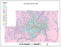
2020-04-10. Metropolitan Council of the Twin Cities Area. The 2020 Generalized Land Use Inventory dataset encompasses the seven county Twin Cities (Minneapolis and St. Paul) Metropolitan Area in Minnesota....
![Generalized Land Use Historical (1984, 1990, 1997, 2000, 2005, 2010, 2016, 2020) [Minnesota]](https://geo.btaa.org/rails/active_storage/representations/redirect/eyJfcmFpbHMiOnsibWVzc2FnZSI6IkJBaHBBbGlMIiwiZXhwIjpudWxsLCJwdXIiOiJibG9iX2lkIn19--c071cbdf309246cc37e9d4f13f25352e274c33b9/eyJfcmFpbHMiOnsibWVzc2FnZSI6IkJBaDdCem9MWm05eWJXRjBTU0lKYW5CbFp3WTZCa1ZVT2hKeVpYTnBlbVZmZEc5ZlptbDBXd2RwQWNndyIsImV4cCI6bnVsbCwicHVyIjoidmFyaWF0aW9uIn19--fb19b03b9eb4e78013d4cfb2b84169f3537e0279/15a50230-0245-41ae-b6fd-fbb2ebc06ba7.jpeg)
2020-04-10. Metropolitan Council of the Twin Cities Area. The Historical Generalized Land Use dataset encompasses the seven county Twin Cities (Minneapolis and St. Paul) Metropolitan Area in Minnesota. The...
2020. MapIT Minneapolis. For questions about this data please contact311OpenData@minneapolismn.govThe data provided are public-facing service requests that were taken by 31...
2019. MapIT Minneapolis. For questions about this data please contact311OpenData@minneapolismn.gov The data provided are public-facing service requests that were taken by 3...
2018. MapIT Minneapolis. For questions about this data please contact311OpenData@minneapolismn.gov The data provided are public-facing service requests that were taken by 3...
2017. MapIT Minneapolis. For questions about this data please contact311OpenData@minneapolismn.gov The data provided are public-facing service requests that were taken by 3...
![Generalized Land Use 2016 [Minnesota]](https://geo.btaa.org/rails/active_storage/representations/redirect/eyJfcmFpbHMiOnsibWVzc2FnZSI6IkJBaHBBbHlMIiwiZXhwIjpudWxsLCJwdXIiOiJibG9iX2lkIn19--63535dcb501ef0b3153d1fe1b48b8f5cf2a86bdd/eyJfcmFpbHMiOnsibWVzc2FnZSI6IkJBaDdCem9MWm05eWJXRjBTU0lKYW5CbFp3WTZCa1ZVT2hKeVpYTnBlbVZmZEc5ZlptbDBXd2RwQWNndyIsImV4cCI6bnVsbCwicHVyIjoidmFyaWF0aW9uIn19--fb19b03b9eb4e78013d4cfb2b84169f3537e0279/249d522a-1f68-4714-8160-a8948df939f6.jpeg)
2016-04-22. Metropolitan Council of the Twin Cities Area. The 2016 Generalized Land Use Inventory dataset encompasses the seven county Twin Cities (Minneapolis and St. Paul) Metropolitan Area in Minnesota....
2016-07-22. Metropolitan Council of the Twin Cities Area. The Land Surface Temperature (LST) raster dataset is a dataset derived from a satellite image from Landsat 8 to show the land surface temperature f...
2016. MapIT Minneapolis. For questions about this data please contact311OpenData@minneapolismn.gov The data provided are public-facing service requests that were taken by 3...
2015. MapIT Minneapolis. For questions about this data please contact311OpenData@minneapolismn.govThe data provided are public-facing service requests that were taken by 31...
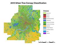
2015. Host, Trevor K., Knight, Joe F., and Rampi, Lian P. A high-resolution (1-meter) tree canopy assessment was completed for the Twin Cities Metropolitan Area. Mapping of existing and potential tree cano...
![2030 Regional Development Framework Planning Areas 2011 [Minnesota]](https://geo.btaa.org/rails/active_storage/representations/redirect/eyJfcmFpbHMiOnsibWVzc2FnZSI6IkJBaHBBZ0p0IiwiZXhwIjpudWxsLCJwdXIiOiJibG9iX2lkIn19--acaa87c7dabf9c6baaec0028a0bc6e48e3e02731/eyJfcmFpbHMiOnsibWVzc2FnZSI6IkJBaDdCem9MWm05eWJXRjBTU0lKYW5CbFp3WTZCa1ZVT2hKeVpYTnBlbVZmZEc5ZlptbDBXd2RwQWNndyIsImV4cCI6bnVsbCwicHVyIjoidmFyaWF0aW9uIn19--fb19b03b9eb4e78013d4cfb2b84169f3537e0279/02236876-9c21-42f6-9870-d2562da8e44f.jpeg)
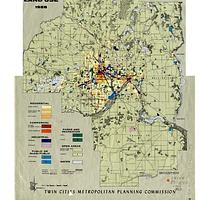
2014-05-23. Metropolitan Council of the Twin Cities Area. The 2030 Regional Development Framework Planning Areas - 2011 updates the 2030 Regional Development Framework Planning Areas initially adopted on J...
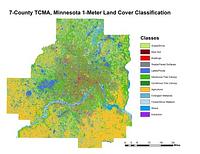
2011-2015. Host, Trevor K., Knight, Joe F., and Rampi, Lian P. A high-resolution (1-meter) land cover classification raster dataset was completed for three different geographic areas in Minnesota: Duluth, Roche... Remote Sensing and Geospatial Analysis Laboratory.
![Generalized Land Use 2010 [Minnesota]](https://geo.btaa.org/rails/active_storage/representations/redirect/eyJfcmFpbHMiOnsibWVzc2FnZSI6IkJBaHBBbHVMIiwiZXhwIjpudWxsLCJwdXIiOiJibG9iX2lkIn19--dde841b25d7e88886ab0f21dcc33df1ff5701cf9/eyJfcmFpbHMiOnsibWVzc2FnZSI6IkJBaDdCem9MWm05eWJXRjBTU0lKYW5CbFp3WTZCa1ZVT2hKeVpYTnBlbVZmZEc5ZlptbDBXd2RwQWNndyIsImV4cCI6bnVsbCwicHVyIjoidmFyaWF0aW9uIn19--fb19b03b9eb4e78013d4cfb2b84169f3537e0279/5c531877-7ab8-4a03-8080-6c59440561d1.jpeg)
2010-04-20. Metropolitan Council of the Twin Cities Area. The 2010 Generalized Land Use Inventory dataset encompasses the seven county Twin Cities (Minneapolis and St. Paul) Metropolitan Area in Minnesota....
2008-04-23. U.S. Geological Survey (USGS). This dataset consists of 0.3-meter pixel resolution (approximately 1-foot), natural color orthoimages covering the Minneapolis-St. Paul urban area ...
![Bikeways [Minnesota]](https://geo.btaa.org/rails/active_storage/representations/redirect/eyJfcmFpbHMiOnsibWVzc2FnZSI6IkJBaHBBdTV3IiwiZXhwIjpudWxsLCJwdXIiOiJibG9iX2lkIn19--6b4dfac6cb3285ebb5a52574a981e0ca3b121fdc/eyJfcmFpbHMiOnsibWVzc2FnZSI6IkJBaDdCem9MWm05eWJXRjBTU0lKYW5CbFp3WTZCa1ZVT2hKeVpYTnBlbVZmZEc5ZlptbDBXd2RwQWNndyIsImV4cCI6bnVsbCwicHVyIjoidmFyaWF0aW9uIn19--fb19b03b9eb4e78013d4cfb2b84169f3537e0279/b83d0f73-a44a-43a5-a108-f029215e635c.jpeg)
2007-04-06. Minnesota Department of Transportation (MNDOT). The regional bikeways dataset was created by the Minnesota Dept of Transportation (MNDOT) in 2003. It has been maintained and updated by the Land M...
![2000 Digital Orthophotos, Twin Cities Metropolitan Area [Minnesota]](https://geo.btaa.org/rails/active_storage/representations/redirect/eyJfcmFpbHMiOnsibWVzc2FnZSI6IkJBaHBBb3B5IiwiZXhwIjpudWxsLCJwdXIiOiJibG9iX2lkIn19--4029bcf6182c6881aa00f760fae3210cdd85d6d5/eyJfcmFpbHMiOnsibWVzc2FnZSI6IkJBaDdCem9MWm05eWJXRjBTU0lKYW5CbFp3WTZCa1ZVT2hKeVpYTnBlbVZmZEc5ZlptbDBXd2RwQWNndyIsImV4cCI6bnVsbCwicHVyIjoidmFyaWF0aW9uIn19--fb19b03b9eb4e78013d4cfb2b84169f3537e0279/016899e5-03ca-487c-90b2-0b5905d6c2e0.jpeg)
2005-05-01. Metropolitan Council of the Twin Cities Area. This dataset contains 267 black and white digital orthophoto quarter-quadrangles (DOQs), 3.75' x 3.75', covering the 7 county Twin Cities (Minneapo...
![Generalized Land Use 2005 [Minnesota]](https://geo.btaa.org/rails/active_storage/representations/redirect/eyJfcmFpbHMiOnsibWVzc2FnZSI6IkJBaHBBbHFMIiwiZXhwIjpudWxsLCJwdXIiOiJibG9iX2lkIn19--c8756a9879899490adab298de6e8279f733552fc/eyJfcmFpbHMiOnsibWVzc2FnZSI6IkJBaDdCem9MWm05eWJXRjBTU0lKYW5CbFp3WTZCa1ZVT2hKeVpYTnBlbVZmZEc5ZlptbDBXd2RwQWNndyIsImV4cCI6bnVsbCwicHVyIjoidmFyaWF0aW9uIn19--fb19b03b9eb4e78013d4cfb2b84169f3537e0279/8eb314dc-9a4e-4d8c-999e-6fdcf401c663.jpeg)
2005-04-14. Metropolitan Council of the Twin Cities Area. The 2005 Generalized Land Use dataset encompasses the seven county Twin Cities (Minneapolis and St. Paul) Metropolitan Area in Minnesota. The data...
2004-04-24. National Geospatial-Intelligence Agency (NGA), U.S. Geological Survey (USGS). This dataset consists of 0.3-meter pixel resolution (approximately 1-foot), natural color orthoimages covering the Minneapolis-St. Paul urban area ...
2000-05-09. Metropolitan Council of the Twin Cities Area. The Aggregate Resources (sand, gravel and limestone and dolomite) dataset contains three separate shape files for aggregate resources for 1997, 202...
![Generalized Land Use 2000 [Minnesota]](https://geo.btaa.org/rails/active_storage/representations/redirect/eyJfcmFpbHMiOnsibWVzc2FnZSI6IkJBaHBBbG1MIiwiZXhwIjpudWxsLCJwdXIiOiJibG9iX2lkIn19--866bf99b41fee6265daf86e4e9e96ac67684969b/eyJfcmFpbHMiOnsibWVzc2FnZSI6IkJBaDdCem9MWm05eWJXRjBTU0lKYW5CbFp3WTZCa1ZVT2hKeVpYTnBlbVZmZEc5ZlptbDBXd2RwQWNndyIsImV4cCI6bnVsbCwicHVyIjoidmFyaWF0aW9uIn19--fb19b03b9eb4e78013d4cfb2b84169f3537e0279/8aac47fc-7f1a-4ab5-ac8b-3659e970c3d8.jpeg)
2000-05-01. Metropolitan Council of the Twin Cities Area. The 2000 Generalized Land Use dataset encompasses the seven county Twin Cities (Minneapolis and St. Paul) Metropolitan Area in Minnesota. The data...
![1997 Digital Orthophotos, Twin Cities Metropolitan Area [Minnesota]](https://geo.btaa.org/rails/active_storage/representations/redirect/eyJfcmFpbHMiOnsibWVzc2FnZSI6IkJBaHBBb2x5IiwiZXhwIjpudWxsLCJwdXIiOiJibG9iX2lkIn19--bb3d81a841dbb92b33474f300ec17132815b2dbb/eyJfcmFpbHMiOnsibWVzc2FnZSI6IkJBaDdCem9MWm05eWJXRjBTU0lKYW5CbFp3WTZCa1ZVT2hKeVpYTnBlbVZmZEc5ZlptbDBXd2RwQWNndyIsImV4cCI6bnVsbCwicHVyIjoidmFyaWF0aW9uIn19--fb19b03b9eb4e78013d4cfb2b84169f3537e0279/019ab9e1-3263-40d2-adc9-10e6f03caa53.jpeg)
1997-04-01. Metropolitan Council of the Twin Cities Area. This dataset contains 265 digital, black and white orthophoto quarter-quadrangles (DOQs), 3.75' x 3.75', covering the 7 county Twin Cities (Minneap...
1990. University of Minnesota. Minnesota Population Center. This boundary file contains historic county boundaries for which the U.S. Census Bureau tabulated data and was produced by the Minnesota Population... National Historical Geographic Information System (NHGIS).
1980. University of Minnesota. Minnesota Population Center. This boundary file contains historic county boundaries for which the U.S. Census Bureau tabulated data and was produced by the Minnesota Population... National Historical Geographic Information System (NHGIS).
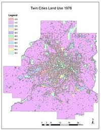
1978. Chen, Wei and Levinson, David M. High-quality GIS land use maps for the Twin Cities Metropolitan Area for 1978 that were developed from paper maps (no GIS version existed previousl...
1970. University of Minnesota. Minnesota Population Center. This boundary file contains historic county boundaries for which the U.S. Census Bureau tabulated data and was produced by the Minnesota Population... National Historical Geographic Information System (NHGIS).
1968. Dan Milz, Jacobs, Paul (Research assistant), Kne, Len, Rebecca Barney, and Ya Tao. A digitized version of Ian McHarg's original 1968 Ecological Study for the Twin Cities Metropolitan Area: Composite Intrinsic Suitability. These ma... U-Spatial.
1968. Chen, Wei and Levinson, David M. High-quality GIS land use maps for the Twin Cities Metropolitan Area for 1968 that were developed from paper maps (no GIS version existed previousl...
1960. University of Minnesota. Minnesota Population Center. This boundary file contains historic county boundaries for which the U.S. Census Bureau tabulated data and was produced by the Minnesota Population... National Historical Geographic Information System (NHGIS).
1958. Chen, Wei and Levinson, David M. High-quality GIS land use maps for the Twin Cities Metropolitan Area for 1958 that were developed from paper maps (no GIS version existed previousl...
1950. University of Minnesota. Minnesota Population Center. This boundary file contains historic county boundaries for which the U.S. Census Bureau tabulated data and was produced by the Minnesota Population... National Historical Geographic Information System (NHGIS).
1940. University of Minnesota. Minnesota Population Center. This boundary file contains historic county boundaries for which the U.S. Census Bureau tabulated data and was produced by the Minnesota Population... National Historical Geographic Information System (NHGIS).
1930. University of Minnesota. Minnesota Population Center. This boundary file contains historic county boundaries for which the U.S. Census Bureau tabulated data and was produced by the Minnesota Population... National Historical Geographic Information System (NHGIS).
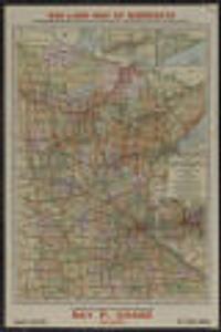
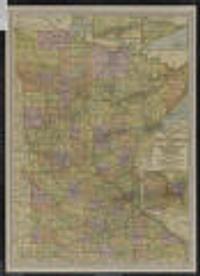
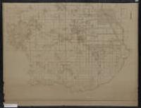
1928. McGill-Warner Co. State lands for sale in 1929 indicated in red.; In each township with a red dot, the state is offering, at public auction, various tracts of state-... McGill-Warner (St. Paul), 1928.
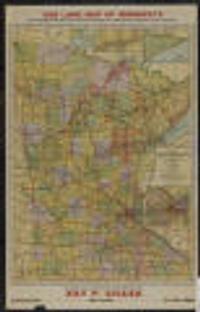
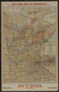
1925-1926. Chase, Ray P. (Ray Park), 1880-1948. State lands for sale in 1926 indicated in red.; "In each township marked with a red dot the state is offering for sale, at public auction, various ... McGill-Warner Co (St. Paul, Minn), 1925.
1925. McGill-Warner Co. State lands for sale in 1927 indicated in red.; In each township with a red dot, the state is offering, at public auction, various tracts of state-... McGill-Warner (St. Paul), 1925.
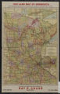
1925. McGill-Warner Co. State lands for sale in 1925 indicated in red.; In each township with a red dot, the state is offering, at public auction, various tracts of state-... McGill-Warner (St. Paul), 1925.
1925. Minnesota State Board of Immigration. Title from outside when folded.; Insets: Mesabi Range.--Cook County, northeastern Minnesota.--St. Paul-Minneapolis and vicinity.; Inset photos on v... Minnesota State Board of Immigration : (St. Paul), 1925.
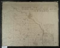
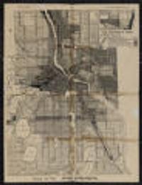
1925. Minneapolis (Minn.). City Planning Commission. Also shows railroads and the Public Land Survey grid. 149 x 102 centimeters 1:36,000 Minneapolis and St. Paul Maps and Atlases. Minneapolis (Minn.). City Planning Commission. (Minneapolis, Minn.?).
1925. Minneapolis (Minn.). City Planning Commission. Also shows railroads and the Public Land Survey grid. 149 x 102 centimeters Scale [1:36,000] 1 inch to 3000 feet Minneapolis and St. Paul Maps and ... The Commission (Minneapolis, Minn.?).
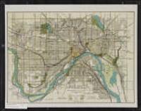
1924. Minneapolis (Minn.). City Planning Commission. Shows districts by type of use. Prime meridian: Greenwich.; Verso: Wisconsin automobile road map.; "140D" in lower right. on sheet 55 x 43 centimet... City Planning Commission (Minneapolis, Minn).
1922. Saint Paul (Minn.). City Planning Board. 43 x 58 centimeters Scale approximately 1:29,000. Minneapolis and St. Paul Maps and Atlases. [The Board], (Saint Paul, Minn.).
1920. University of Minnesota. Minnesota Population Center. This boundary file contains historic county boundaries for which the U.S. Census Bureau tabulated data and was produced by the Minnesota Population... National Historical Geographic Information System (NHGIS).
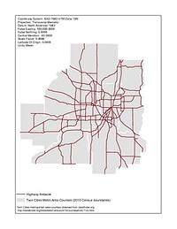
1920-1995. Chen, Wei and Levinson, David M. Illustrates the development of the highway network in the Twin Cities metropolitan region. GIS maps of the state highway network were created for 1...
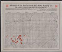
Shows locations of settlers, school houses, creameries, and cheese factories; also shows Soo Line railroad.; "Lands colored red are offered for sal... Minneapolis, St. Paul and Sault Ste. Marie Railway Co (Minneapolis, Minn).
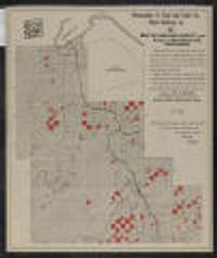
1915-1925?. Shows locations of school houses, churches, farms, and Bad River Indian Reservation; also shows Soo Line railroad and part of Chequamegon Bay.; "La... Minneapolis, St. Paul and Sault Ste. Marie Railway Co (Minneapolis, Minn).