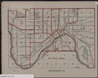
1. 1-Foot Contours, Burnsville [Minnesota--Dakota County]
![1-Foot Contours, Burnsville [Minnesota--Dakota County]](https://geo.btaa.org/rails/active_storage/representations/redirect/eyJfcmFpbHMiOnsibWVzc2FnZSI6IkJBaHBBdmhzIiwiZXhwIjpudWxsLCJwdXIiOiJibG9iX2lkIn19--3ae274a51f8984aef6b81f33594b3dc821c73a47/eyJfcmFpbHMiOnsibWVzc2FnZSI6IkJBaDdCem9MWm05eWJXRjBTU0lKYW5CbFp3WTZCa1ZVT2hKeVpYTnBlbVZmZEc5ZlptbDBXd2RwQWNndyIsImV4cCI6bnVsbCwicHVyIjoidmFyaWF0aW9uIn19--fb19b03b9eb4e78013d4cfb2b84169f3537e0279/4f370ad1-038f-4c47-91ef-89740d98ed28.jpeg)
Minnesota--Dakota County. Fugro Horizons Inc. acquired highly accurate Light Detection and Ranging (LiDAR) elevation data for the Twin Cities metropolitan region in east-cen...
Minnesota--Dakota County. Fugro Horizons Inc. acquired highly accurate Light Detection and Ranging (LiDAR) elevation data for the Twin Cities metropolitan region in east-cen...
![1-Foot Contours, Eagan [Minnesota--Dakota County]](https://geo.btaa.org/rails/active_storage/representations/redirect/eyJfcmFpbHMiOnsibWVzc2FnZSI6IkJBaHBBdmxzIiwiZXhwIjpudWxsLCJwdXIiOiJibG9iX2lkIn19--9d0eeca808288166719099036cd51a4b3baae91b/eyJfcmFpbHMiOnsibWVzc2FnZSI6IkJBaDdCem9MWm05eWJXRjBTU0lKYW5CbFp3WTZCa1ZVT2hKeVpYTnBlbVZmZEc5ZlptbDBXd2RwQWNndyIsImV4cCI6bnVsbCwicHVyIjoidmFyaWF0aW9uIn19--fb19b03b9eb4e78013d4cfb2b84169f3537e0279/95e9a1cb-ebf0-42b5-9311-d55c729d2aad.jpeg)
Minnesota--Dakota County. Fugro Horizons Inc. acquired highly accurate Light Detection and Ranging (LiDAR) elevation data for the Twin Cities metropolitan region in east-cen...
![1-Foot Contours, Apple Valley [Minnesota--Dakota County]](https://geo.btaa.org/rails/active_storage/representations/redirect/eyJfcmFpbHMiOnsibWVzc2FnZSI6IkJBaHBBdmRzIiwiZXhwIjpudWxsLCJwdXIiOiJibG9iX2lkIn19--6bc7643f2e7ef9605555a3116c64f3c71a679341/eyJfcmFpbHMiOnsibWVzc2FnZSI6IkJBaDdCem9MWm05eWJXRjBTU0lKYW5CbFp3WTZCa1ZVT2hKeVpYTnBlbVZmZEc5ZlptbDBXd2RwQWNndyIsImV4cCI6bnVsbCwicHVyIjoidmFyaWF0aW9uIn19--fb19b03b9eb4e78013d4cfb2b84169f3537e0279/26287ad9-7d76-4bce-b775-0bf192ac4f19.jpeg)
Minnesota--Dakota County. Fugro Horizons Inc. acquired highly accurate Light Detection and Ranging (LiDAR) elevation data for the Twin Cities metropolitan region in east-cen...
![1-Foot Contours, Inver Grove Heights [Minnesota--Dakota County]](https://geo.btaa.org/rails/active_storage/representations/redirect/eyJfcmFpbHMiOnsibWVzc2FnZSI6IkJBaHBBdnRzIiwiZXhwIjpudWxsLCJwdXIiOiJibG9iX2lkIn19--603f523fbef33e361341e389a6337d7e47569cf2/eyJfcmFpbHMiOnsibWVzc2FnZSI6IkJBaDdCem9MWm05eWJXRjBTU0lKYW5CbFp3WTZCa1ZVT2hKeVpYTnBlbVZmZEc5ZlptbDBXd2RwQWNndyIsImV4cCI6bnVsbCwicHVyIjoidmFyaWF0aW9uIn19--fb19b03b9eb4e78013d4cfb2b84169f3537e0279/bef15d54-e213-4441-97b8-b0f8244d67cf.jpeg)
Minnesota--Dakota County. Fugro Horizons Inc. acquired highly accurate Light Detection and Ranging (LiDAR) elevation data for the Twin Cities metropolitan region in east-cen...
![1-Foot Contours, Farmington [Minnesota--Dakota County]](https://geo.btaa.org/rails/active_storage/representations/redirect/eyJfcmFpbHMiOnsibWVzc2FnZSI6IkJBaHBBdnBzIiwiZXhwIjpudWxsLCJwdXIiOiJibG9iX2lkIn19--b5005951425b1bfcea67ad29c4bec3199be50e19/eyJfcmFpbHMiOnsibWVzc2FnZSI6IkJBaDdCem9MWm05eWJXRjBTU0lKYW5CbFp3WTZCa1ZVT2hKeVpYTnBlbVZmZEc5ZlptbDBXd2RwQWNndyIsImV4cCI6bnVsbCwicHVyIjoidmFyaWF0aW9uIn19--fb19b03b9eb4e78013d4cfb2b84169f3537e0279/5479f6be-b8e0-445d-995e-2b9a04189937.jpeg)
Minnesota--Dakota County. Fugro Horizons Inc. acquired highly accurate Light Detection and Ranging (LiDAR) elevation data for the Twin Cities metropolitan region in east-cen...
![1-Foot Contours, Rosemount [Minnesota--Dakota County]](https://geo.btaa.org/rails/active_storage/representations/redirect/eyJfcmFpbHMiOnsibWVzc2FnZSI6IkJBaHBBdjFzIiwiZXhwIjpudWxsLCJwdXIiOiJibG9iX2lkIn19--b21bcf2cb6084c60b9095ded84bac0d5fb4c337b/eyJfcmFpbHMiOnsibWVzc2FnZSI6IkJBaDdCem9MWm05eWJXRjBTU0lKYW5CbFp3WTZCa1ZVT2hKeVpYTnBlbVZmZEc5ZlptbDBXd2RwQWNndyIsImV4cCI6bnVsbCwicHVyIjoidmFyaWF0aW9uIn19--fb19b03b9eb4e78013d4cfb2b84169f3537e0279/ac495b7c-9243-4087-9cd9-69e0f1562673.jpeg)
Minnesota--Dakota County. Fugro Horizons Inc. acquired highly accurate Light Detection and Ranging (LiDAR) elevation data for the Twin Cities metropolitan region in east-cen...
![1-Foot Contours, West St Paul [Minnesota--Dakota County]](https://geo.btaa.org/rails/active_storage/representations/redirect/eyJfcmFpbHMiOnsibWVzc2FnZSI6IkJBaHBBdjlzIiwiZXhwIjpudWxsLCJwdXIiOiJibG9iX2lkIn19--f0feb29c979540b692aa472fd9c14684584ea948/eyJfcmFpbHMiOnsibWVzc2FnZSI6IkJBaDdCem9MWm05eWJXRjBTU0lKYW5CbFp3WTZCa1ZVT2hKeVpYTnBlbVZmZEc5ZlptbDBXd2RwQWNndyIsImV4cCI6bnVsbCwicHVyIjoidmFyaWF0aW9uIn19--fb19b03b9eb4e78013d4cfb2b84169f3537e0279/eaa0f485-18ae-4dbd-ab2a-91f112f23fdc.jpeg)
Minnesota--Dakota County. Fugro Horizons Inc. acquired highly accurate Light Detection and Ranging (LiDAR) elevation data for the Twin Cities metropolitan region in east-cen...
![1-Foot Contours, South St Paul [Minnesota--Dakota County]](https://geo.btaa.org/rails/active_storage/representations/redirect/eyJfcmFpbHMiOnsibWVzc2FnZSI6IkJBaHBBdjVzIiwiZXhwIjpudWxsLCJwdXIiOiJibG9iX2lkIn19--0ba2b040abbbc407d8dde021179f05a31e0353d9/eyJfcmFpbHMiOnsibWVzc2FnZSI6IkJBaDdCem9MWm05eWJXRjBTU0lKYW5CbFp3WTZCa1ZVT2hKeVpYTnBlbVZmZEc5ZlptbDBXd2RwQWNndyIsImV4cCI6bnVsbCwicHVyIjoidmFyaWF0aW9uIn19--fb19b03b9eb4e78013d4cfb2b84169f3537e0279/e840be7c-d2ab-4011-8e73-05e7cee5beb1.jpeg)
Minnesota--Dakota County. Fugro Horizons Inc. acquired highly accurate Light Detection and Ranging (LiDAR) elevation data for the Twin Cities metropolitan region in east-cen...
![1-Foot Contours, Mendota Heights [Minnesota--Dakota County]](https://geo.btaa.org/rails/active_storage/representations/redirect/eyJfcmFpbHMiOnsibWVzc2FnZSI6IkJBaHBBdnhzIiwiZXhwIjpudWxsLCJwdXIiOiJibG9iX2lkIn19--4e715f0800cae8e03515996bc7f29287a10e5a27/eyJfcmFpbHMiOnsibWVzc2FnZSI6IkJBaDdCem9MWm05eWJXRjBTU0lKYW5CbFp3WTZCa1ZVT2hKeVpYTnBlbVZmZEc5ZlptbDBXd2RwQWNndyIsImV4cCI6bnVsbCwicHVyIjoidmFyaWF0aW9uIn19--fb19b03b9eb4e78013d4cfb2b84169f3537e0279/50191afd-9f5f-418a-8bc8-8ebcb38e4175.jpeg)
Minnesota--Dakota County. Fugro Horizons Inc. acquired highly accurate Light Detection and Ranging (LiDAR) elevation data for the Twin Cities metropolitan region in east-cen...
Metropolitan Council and the U.S. Census Bureau. Summary File 3 Data Profile 3 (SF3 Table DP-3) for Minneapolis-St. Paul 7 County metropolitan area is a subset of the profile of selected economic ...
Metropolitan Council and the U.S. Census Bureau. Summary File 3 Data Profile 2 (SF3 Table DP-2) for Census Tracts in Minneapolis-St. Paul 7 County metropolitan area is a subset of the profile of s...
Metropolitan Council and the U.S. Census Bureau. Summary File 1 Data Profile 1 (SF1 Table DP-1) for Census Tracts in the Minneapolis-St. Paul 7 County metropolitan area is a subset of the profile ...
Metropolitan Council and the U.S. Census Bureau. Summary File 3 Data Profile 4 (SF3 Table DP-4) for Census Tracts in the Minneapolis-St. Paul 7 County metropolitan area is a subset of the profile ...
![Racial Covenants [Hennepin County, Minnesota] (1910-1955)](https://geo.btaa.org/rails/active_storage/representations/redirect/eyJfcmFpbHMiOnsibWVzc2FnZSI6IkJBaHBBZ05wIiwiZXhwIjpudWxsLCJwdXIiOiJibG9iX2lkIn19--6b92ffee4333718a6c6e2f09654bbde875876e28/eyJfcmFpbHMiOnsibWVzc2FnZSI6IkJBaDdCem9MWm05eWJXRjBTU0lKYW5CbFp3WTZCa1ZVT2hKeVpYTnBlbVZmZEc5ZlptbDBXd2RwQWNndyIsImV4cCI6bnVsbCwicHVyIjoidmFyaWF0aW9uIn19--fb19b03b9eb4e78013d4cfb2b84169f3537e0279/0455d309-e4e9-473e-8c3f-b42a6a2e16fc.jpeg)
1910-1955. Delegard, Kirsten, Ehrman-Solberg, Kevin, Mattke, Ryan, Mills, Marguerite, and Petersen, Penny. This data was compiled by the Mapping Prejudice Project and shows the location of racial covenants recorded in Hennepin County between 1910 and 195... University of Minnesota Mapping Prejudice Project.
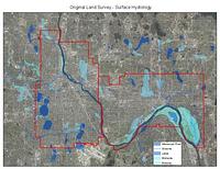
1848-1858. Graves, Richard (Professor of architecture), Kernik, Melinda, Kne, Len, Mattke, Ryan, Shepard, Coleman, and Strong, Richard (Professor of architecture). These shapefiles of lakes, streams, wetlands, river bottoms, and the Mississippi River represent the hydrological landscape of Minneapolis and St. ...
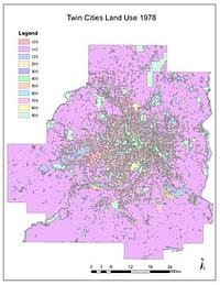
1978. Chen, Wei and Levinson, David M. High-quality GIS land use maps for the Twin Cities Metropolitan Area for 1978 that were developed from paper maps (no GIS version existed previousl...
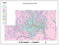
1968. Chen, Wei and Levinson, David M. High-quality GIS land use maps for the Twin Cities Metropolitan Area for 1968 that were developed from paper maps (no GIS version existed previousl...
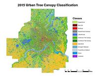
2015. Host, Trevor K., Knight, Joe F., and Rampi, Lian P. A high-resolution (1-meter) tree canopy assessment was completed for the Twin Cities Metropolitan Area. Mapping of existing and potential tree cano...
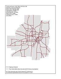
1920-1995. Chen, Wei and Levinson, David M. Illustrates the development of the highway network in the Twin Cities metropolitan region. GIS maps of the state highway network were created for 1...
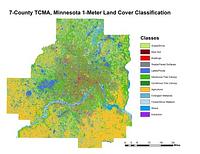
2011-2015. Host, Trevor K., Knight, Joe F., and Rampi, Lian P. A high-resolution (1-meter) land cover classification raster dataset was completed for three different geographic areas in Minnesota: Duluth, Roche... Remote Sensing and Geospatial Analysis Laboratory.
![Bikeways [Minnesota]](https://geo.btaa.org/rails/active_storage/representations/redirect/eyJfcmFpbHMiOnsibWVzc2FnZSI6IkJBaHBBdTV3IiwiZXhwIjpudWxsLCJwdXIiOiJibG9iX2lkIn19--6b4dfac6cb3285ebb5a52574a981e0ca3b121fdc/eyJfcmFpbHMiOnsibWVzc2FnZSI6IkJBaDdCem9MWm05eWJXRjBTU0lKYW5CbFp3WTZCa1ZVT2hKeVpYTnBlbVZmZEc5ZlptbDBXd2RwQWNndyIsImV4cCI6bnVsbCwicHVyIjoidmFyaWF0aW9uIn19--fb19b03b9eb4e78013d4cfb2b84169f3537e0279/b83d0f73-a44a-43a5-a108-f029215e635c.jpeg)
2007-04-06. Minnesota Department of Transportation (MNDOT). The regional bikeways dataset was created by the Minnesota Dept of Transportation (MNDOT) in 2003. It has been maintained and updated by the Land M...
2000-05-09. Metropolitan Council of the Twin Cities Area. The Aggregate Resources (sand, gravel and limestone and dolomite) dataset contains three separate shape files for aggregate resources for 1997, 202...
![2030 Regional Development Framework Planning Areas 2011 [Minnesota]](https://geo.btaa.org/rails/active_storage/representations/redirect/eyJfcmFpbHMiOnsibWVzc2FnZSI6IkJBaHBBZ0p0IiwiZXhwIjpudWxsLCJwdXIiOiJibG9iX2lkIn19--acaa87c7dabf9c6baaec0028a0bc6e48e3e02731/eyJfcmFpbHMiOnsibWVzc2FnZSI6IkJBaDdCem9MWm05eWJXRjBTU0lKYW5CbFp3WTZCa1ZVT2hKeVpYTnBlbVZmZEc5ZlptbDBXd2RwQWNndyIsImV4cCI6bnVsbCwicHVyIjoidmFyaWF0aW9uIn19--fb19b03b9eb4e78013d4cfb2b84169f3537e0279/02236876-9c21-42f6-9870-d2562da8e44f.jpeg)
2014-05-23. Metropolitan Council of the Twin Cities Area. The 2030 Regional Development Framework Planning Areas - 2011 updates the 2030 Regional Development Framework Planning Areas initially adopted on J...
![Generalized Land Use Historical (1984, 1990, 1997, 2000, 2005, 2010, 2016, 2020) [Minnesota]](https://geo.btaa.org/rails/active_storage/representations/redirect/eyJfcmFpbHMiOnsibWVzc2FnZSI6IkJBaHBBbGlMIiwiZXhwIjpudWxsLCJwdXIiOiJibG9iX2lkIn19--c071cbdf309246cc37e9d4f13f25352e274c33b9/eyJfcmFpbHMiOnsibWVzc2FnZSI6IkJBaDdCem9MWm05eWJXRjBTU0lKYW5CbFp3WTZCa1ZVT2hKeVpYTnBlbVZmZEc5ZlptbDBXd2RwQWNndyIsImV4cCI6bnVsbCwicHVyIjoidmFyaWF0aW9uIn19--fb19b03b9eb4e78013d4cfb2b84169f3537e0279/15a50230-0245-41ae-b6fd-fbb2ebc06ba7.jpeg)
2020-04-10. Metropolitan Council of the Twin Cities Area. The Historical Generalized Land Use dataset encompasses the seven county Twin Cities (Minneapolis and St. Paul) Metropolitan Area in Minnesota. The...
![Generalized Land Use 2000 [Minnesota]](https://geo.btaa.org/rails/active_storage/representations/redirect/eyJfcmFpbHMiOnsibWVzc2FnZSI6IkJBaHBBbG1MIiwiZXhwIjpudWxsLCJwdXIiOiJibG9iX2lkIn19--866bf99b41fee6265daf86e4e9e96ac67684969b/eyJfcmFpbHMiOnsibWVzc2FnZSI6IkJBaDdCem9MWm05eWJXRjBTU0lKYW5CbFp3WTZCa1ZVT2hKeVpYTnBlbVZmZEc5ZlptbDBXd2RwQWNndyIsImV4cCI6bnVsbCwicHVyIjoidmFyaWF0aW9uIn19--fb19b03b9eb4e78013d4cfb2b84169f3537e0279/8aac47fc-7f1a-4ab5-ac8b-3659e970c3d8.jpeg)
2000-05-01. Metropolitan Council of the Twin Cities Area. The 2000 Generalized Land Use dataset encompasses the seven county Twin Cities (Minneapolis and St. Paul) Metropolitan Area in Minnesota. The data...
![Generalized Land Use 2016 [Minnesota]](https://geo.btaa.org/rails/active_storage/representations/redirect/eyJfcmFpbHMiOnsibWVzc2FnZSI6IkJBaHBBbHlMIiwiZXhwIjpudWxsLCJwdXIiOiJibG9iX2lkIn19--63535dcb501ef0b3153d1fe1b48b8f5cf2a86bdd/eyJfcmFpbHMiOnsibWVzc2FnZSI6IkJBaDdCem9MWm05eWJXRjBTU0lKYW5CbFp3WTZCa1ZVT2hKeVpYTnBlbVZmZEc5ZlptbDBXd2RwQWNndyIsImV4cCI6bnVsbCwicHVyIjoidmFyaWF0aW9uIn19--fb19b03b9eb4e78013d4cfb2b84169f3537e0279/249d522a-1f68-4714-8160-a8948df939f6.jpeg)
2016-04-22. Metropolitan Council of the Twin Cities Area. The 2016 Generalized Land Use Inventory dataset encompasses the seven county Twin Cities (Minneapolis and St. Paul) Metropolitan Area in Minnesota....
![Generalized Land Use 2010 [Minnesota]](https://geo.btaa.org/rails/active_storage/representations/redirect/eyJfcmFpbHMiOnsibWVzc2FnZSI6IkJBaHBBbHVMIiwiZXhwIjpudWxsLCJwdXIiOiJibG9iX2lkIn19--dde841b25d7e88886ab0f21dcc33df1ff5701cf9/eyJfcmFpbHMiOnsibWVzc2FnZSI6IkJBaDdCem9MWm05eWJXRjBTU0lKYW5CbFp3WTZCa1ZVT2hKeVpYTnBlbVZmZEc5ZlptbDBXd2RwQWNndyIsImV4cCI6bnVsbCwicHVyIjoidmFyaWF0aW9uIn19--fb19b03b9eb4e78013d4cfb2b84169f3537e0279/5c531877-7ab8-4a03-8080-6c59440561d1.jpeg)
2010-04-20. Metropolitan Council of the Twin Cities Area. The 2010 Generalized Land Use Inventory dataset encompasses the seven county Twin Cities (Minneapolis and St. Paul) Metropolitan Area in Minnesota....
![Generalized Land Use 2005 [Minnesota]](https://geo.btaa.org/rails/active_storage/representations/redirect/eyJfcmFpbHMiOnsibWVzc2FnZSI6IkJBaHBBbHFMIiwiZXhwIjpudWxsLCJwdXIiOiJibG9iX2lkIn19--c8756a9879899490adab298de6e8279f733552fc/eyJfcmFpbHMiOnsibWVzc2FnZSI6IkJBaDdCem9MWm05eWJXRjBTU0lKYW5CbFp3WTZCa1ZVT2hKeVpYTnBlbVZmZEc5ZlptbDBXd2RwQWNndyIsImV4cCI6bnVsbCwicHVyIjoidmFyaWF0aW9uIn19--fb19b03b9eb4e78013d4cfb2b84169f3537e0279/8eb314dc-9a4e-4d8c-999e-6fdcf401c663.jpeg)
2005-04-14. Metropolitan Council of the Twin Cities Area. The 2005 Generalized Land Use dataset encompasses the seven county Twin Cities (Minneapolis and St. Paul) Metropolitan Area in Minnesota. The data...
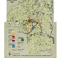
![Metropolitan Urban Service Areas (MUSA) Composite [Minnesota]](https://geo.btaa.org/rails/active_storage/representations/redirect/eyJfcmFpbHMiOnsibWVzc2FnZSI6IkJBaHBBaFdXIiwiZXhwIjpudWxsLCJwdXIiOiJibG9iX2lkIn19--aff95d9a14879dcfe505de79fd4665a571b4df3d/eyJfcmFpbHMiOnsibWVzc2FnZSI6IkJBaDdCem9MWm05eWJXRjBTU0lKYW5CbFp3WTZCa1ZVT2hKeVpYTnBlbVZmZEc5ZlptbDBXd2RwQWNndyIsImV4cCI6bnVsbCwicHVyIjoidmFyaWF0aW9uIn19--fb19b03b9eb4e78013d4cfb2b84169f3537e0279/3fd08f21-f937-4b7d-b89a-3c7dfd0f15f3.jpeg)
2024-01-19. Metropolitan Council of the Twin Cities Area. The MUSA Composite dataset depicts current and future boundaries of the Urban Service Areas (sewer service areas) based on communities' comprehensi...
2024-01-19. Metropolitan Council of the Twin Cities Area. The ThriveMSP 2040 Community Designations was adopted on May 28, 2014. This dataset reflects the agreed upon community designation between a commun...
1958. Chen, Wei and Levinson, David M. High-quality GIS land use maps for the Twin Cities Metropolitan Area for 1958 that were developed from paper maps (no GIS version existed previousl...
![2000 Digital Orthophotos, Twin Cities Metropolitan Area [Minnesota]](https://geo.btaa.org/rails/active_storage/representations/redirect/eyJfcmFpbHMiOnsibWVzc2FnZSI6IkJBaHBBb3B5IiwiZXhwIjpudWxsLCJwdXIiOiJibG9iX2lkIn19--4029bcf6182c6881aa00f760fae3210cdd85d6d5/eyJfcmFpbHMiOnsibWVzc2FnZSI6IkJBaDdCem9MWm05eWJXRjBTU0lKYW5CbFp3WTZCa1ZVT2hKeVpYTnBlbVZmZEc5ZlptbDBXd2RwQWNndyIsImV4cCI6bnVsbCwicHVyIjoidmFyaWF0aW9uIn19--fb19b03b9eb4e78013d4cfb2b84169f3537e0279/016899e5-03ca-487c-90b2-0b5905d6c2e0.jpeg)
2005-05-01. Metropolitan Council of the Twin Cities Area. This dataset contains 267 black and white digital orthophoto quarter-quadrangles (DOQs), 3.75' x 3.75', covering the 7 county Twin Cities (Minneapo...
![1997 Digital Orthophotos, Twin Cities Metropolitan Area [Minnesota]](https://geo.btaa.org/rails/active_storage/representations/redirect/eyJfcmFpbHMiOnsibWVzc2FnZSI6IkJBaHBBb2x5IiwiZXhwIjpudWxsLCJwdXIiOiJibG9iX2lkIn19--bb3d81a841dbb92b33474f300ec17132815b2dbb/eyJfcmFpbHMiOnsibWVzc2FnZSI6IkJBaDdCem9MWm05eWJXRjBTU0lKYW5CbFp3WTZCa1ZVT2hKeVpYTnBlbVZmZEc5ZlptbDBXd2RwQWNndyIsImV4cCI6bnVsbCwicHVyIjoidmFyaWF0aW9uIn19--fb19b03b9eb4e78013d4cfb2b84169f3537e0279/019ab9e1-3263-40d2-adc9-10e6f03caa53.jpeg)
1997-04-01. Metropolitan Council of the Twin Cities Area. This dataset contains 265 digital, black and white orthophoto quarter-quadrangles (DOQs), 3.75' x 3.75', covering the 7 county Twin Cities (Minneap...
2004-04-24. National Geospatial-Intelligence Agency (NGA), U.S. Geological Survey (USGS). This dataset consists of 0.3-meter pixel resolution (approximately 1-foot), natural color orthoimages covering the Minneapolis-St. Paul urban area ...
U.S. Geological Survey (USGS) and Digital Aerial Solutions, LLC. This dataset consists of 0.3-meter pixel resolution (approximately 1-foot), natural color orthoimages covering the Minneapolis-St. Paul urban area ...
2008-04-23. U.S. Geological Survey (USGS). This dataset consists of 0.3-meter pixel resolution (approximately 1-foot), natural color orthoimages covering the Minneapolis-St. Paul urban area ...
U.S. Geological Survey (USGS). This dataset consists of 0.3-meter pixel resolution (approximately 1-foot), natural color orthoimages covering 1/3 of the Minneapolis-St. Paul urb...
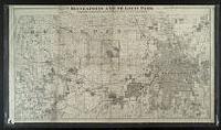
![Davisons [sic] map 25 miles around Minneapolis : 1881 corrected to 1884](https://geo.btaa.org/rails/active_storage/representations/redirect/eyJfcmFpbHMiOnsibWVzc2FnZSI6IkJBaHBBbDF5IiwiZXhwIjpudWxsLCJwdXIiOiJibG9iX2lkIn19--e2a371359b0a0b478005b350887b5a48c3690be0/eyJfcmFpbHMiOnsibWVzc2FnZSI6IkJBaDdCem9MWm05eWJXRjBTU0lKYW5CbFp3WTZCa1ZVT2hKeVpYTnBlbVZmZEc5ZlptbDBXd2RwQWNndyIsImV4cCI6bnVsbCwicHVyIjoidmFyaWF0aW9uIn19--fb19b03b9eb4e78013d4cfb2b84169f3537e0279/p16022coll245-869.jpeg)
1884. Cooley, George Washington (1845-1920). Shows metropolitan area of both Minneapolis and Saint Paul. Also shows railroad lines, roads, Public Land Survey townships and sections, cemeteries... C. Wright Davison. Lith. By Johnson, Smith & Harrison (Minneapolis, Minn.), 1881.
![Davisons [sic] map 25 miles around the Twin Cities : 1881 corrected to 1889](https://geo.btaa.org/rails/active_storage/representations/redirect/eyJfcmFpbHMiOnsibWVzc2FnZSI6IkJBaHBBbDV5IiwiZXhwIjpudWxsLCJwdXIiOiJibG9iX2lkIn19--1cfa66af7e0468ba51cd76e61726920357368cc6/eyJfcmFpbHMiOnsibWVzc2FnZSI6IkJBaDdCem9MWm05eWJXRjBTU0lKYW5CbFp3WTZCa1ZVT2hKeVpYTnBlbVZmZEc5ZlptbDBXd2RwQWNndyIsImV4cCI6bnVsbCwicHVyIjoidmFyaWF0aW9uIn19--fb19b03b9eb4e78013d4cfb2b84169f3537e0279/p16022coll245-896.jpeg)
1889. Cooley, George Washington (1845-1920). Also shows railroad lines, roads, Public Land Survey townships and sections, cemeteries, churches, and schools. Entered according to act of Congres... C. Wright Davison, Minneapolis Directory Co (Minneapolis, Minn.?), 1881.
1898-1904. United States. Mississippi River Commission. Survey of the Mississippi River; made under the direction of the Mississippi River Commission. Contains Charts 241-278. Each chart is at a scale of... Mississippi River Commission.

1898-1904. United States. Mississippi River Commission. Survey of the Mississippi River; made under the direction of the Mississippi River Commission. Contains Charts 201-240. Each chart is at a scale of... Mississippi River Commission.
1876-1899. United States. Mississippi River Commission. Survey of the Mississippi River; made under the direction of the Mississippi River Commission. Contains Charts 101-134. Each chart is at a scale of... Mississippi River Commission.
1876-1899. United States. Mississippi River Commission. Survey of the Mississippi River; made under the direction of the Mississippi River Commission. Contains Charts 135-148, 150, 152-165, 167-168, 170-... Mississippi River Commission.
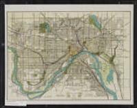
1880. Bourquin, Frederick, 1808-, Bracher, William, and Warner & Foote. Cartographic Details: Scale approximately 1:57,000. Facsimile: location of original and date of reproduction unknown. Scale of original [1:45,258],... Warner & Foote (Minneapolis, Minnesota), 1880.
1880. Johnson, Smith & Harrison., Wright, Charles J., -1913), and Wright, George Burdick, 1832-1882. Cartographic Details: Scale approximately 1:255,000. Relief shown by hachures. Scale provided from another source. Map does not indicate scale. "Ge... Geo. B. Wright (Minneapolis, Minnesota), 1880.
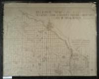
1892?. Minneapolis Land & Investment Co. (Minneapolis, Minn.). Plat information as of 1890, railroad lines as of 1892. Area shown includes western and central Hennepin Co. and the western edge of St. Paul shows...
1922. Saint Paul (Minn.). City Planning Board. 43 x 58 centimeters Scale approximately 1:29,000. Minneapolis and St. Paul Maps and Atlases. [The Board], (Saint Paul, Minn.).
1925. Minneapolis (Minn.). City Planning Commission. Also shows railroads and the Public Land Survey grid. 149 x 102 centimeters 1:36,000 Minneapolis and St. Paul Maps and Atlases. Minneapolis (Minn.). City Planning Commission. (Minneapolis, Minn.?).
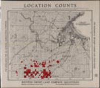
1910-1919. Western Empire Land Company. Cartographic Details: Scale not given. "Lands in red for sale by Western Empire Land Co., Minneapolis, Minn." Covers the northeast portion of Carlt... Western Empire Land Company (Minneapolis, Minnesota).
approximately 1912. Cartographic Details: Scale not given. Also shows parks, cemeteries, railroads, and Public Land Survey grid. 19 x 26 centimeters Minneapolis and St...