1. Zwingle; Sylva
1892. North West Publishing Co.
1892. North West Publishing Co.
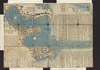
Abe, Rekisai, Sobajima, Seishin, publisher., and Takada, Shinshō, publisher. 1 map : col. ; 75 x 106 cm., folded in covers 26 x 18 cm. Wood block print. Relief shown pictorially. Oriented with north to the left. Date of publ...
Continually updated resource. Sauk County. City of Baraboo Zoning Districts.
2017. Wisconsin--Vilas County. These polygon data layers represent zoning for Vilas County, Wisconsin at year-end 2016. They are feature classes within the geodatabase Vilas_Zoni...
2017. Wisconsin--Wood County. This polygon data layer represents floodplain zoning for Wood County, Wisconsin in 2017. It is a feature class within the geodatabase, Wood_Zoning_...
2016. Wisconsin--Wood County. This polygon data layer represents zoning as FEMA flood hazards for Wood County, Wisconsin in 2016. It is a feature class within the geodatabase, W...
2020. Wisconsin--Wisconsin Rapids. This data represents zoning for the City of Wisconsin Rapids, Wisconsin in 2020. This is an archived copy of the data held at UW-Madison. For acces...
2023. Wisconsin--Winnebago County. This data represents zoning for Winnebago County, Wisconsin in 2023 and includes the 'Winnebago_General_2023,' and 'Winnebago_Shoreland_2023.' This...
2022. Wisconsin--Winnebago County. This data represents zoning for Winnebago County, Wisconsin in 2022 and includes the 'Winnebago_General_2022,' and 'Winnebago_Shoreland_2022.' This...
2021. Wisconsin--Winnebago County. This data represents zoning for Winnebago County, Wisconsin in 2021 and includes the layers 'Winnebago_Airport_2021,' 'Winnebago_General_2021,' and...