1. [Insurance maps of Ann Arbor, Washtenaw Co., Michigan
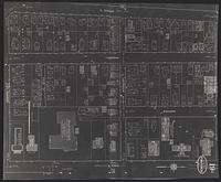
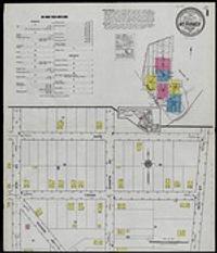
1916. Sanborn Map Company. Sanborn Map Company, June 1916]. Negative photostat of University of Michigan central campus area. 1 map: photstat; sheets 49 x 40 cm.
1916. Sanborn Map Company. Sanborn Map Company, June 1916]. Negative photostat of University of Michigan central campus area. 1 map: photstat; sheets 49 x 40 cm.
2018. Wisconsin--Sauk County. This data layer represents buildings for Sauk County, Wisconsin in 2018. It is a feature class within the geodatabase, 'Sauk_Buildings_2018.gdb'. [...
2020. Wisconsin--Sauk County. This data layer represents buildings for Sauk County, Wisconsin in 2020. [The creation of the subsequent building footprint data was executed to ca...
2017. Wisconsin--Sauk County. This polygon data layer represents buildings in Sauk County, Wisconsin at year-end 2016. It is a feature class within the geodatabase, Sauk_Buildin...
2019. Wisconsin--Sauk County. This data layer represents buildings for Sauk County, Wisconsin in 2019. [The creation of the subsequent building footprint data was executed to ca...
![High Resolution Orthoimagery, Spring 2018 [Minnesota--Hennepin County]](https://geo.btaa.org/rails/active_storage/representations/redirect/eyJfcmFpbHMiOnsibWVzc2FnZSI6IkJBaHBBdkdNIiwiZXhwIjpudWxsLCJwdXIiOiJibG9iX2lkIn19--d3064ebbe6cd7d93a93d003b1014e2ea496a5974/eyJfcmFpbHMiOnsibWVzc2FnZSI6IkJBaDdCem9MWm05eWJXRjBTU0lKYW5CbFp3WTZCa1ZVT2hKeVpYTnBlbVZmZEc5ZlptbDBXd2RwQWNndyIsImV4cCI6bnVsbCwicHVyIjoidmFyaWF0aW9uIn19--fb19b03b9eb4e78013d4cfb2b84169f3537e0279/d2d3e11d-c902-4f4f-8b97-cb6a06516a9d.jpeg)
Minnesota--Hennepin County. This dataset contains leaf-off natural color digital orthophoto imagery produced at 3-inch resolution from new aerial photography captured in May 2...
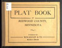
1921. W.W. Hixson & Co. Plat book of Redwood County, Minnesota, containing an outline map of the county and plats of all townships showing location of roads, schools, chur... W.W. Hixson & Co.

1816-2002. Indiana Historic Maps provides images of a small portion of maps that focus on Indiana. The majority of this collection focuses on maps produced pr...
The Indiana Spatial Data Portal (ISDP) provides access to more than 30 terabytes of Indiana geospatial data. Most datasets are available to the pub... Indiana University.
2007. Geological Survey (U.S.) and Sanborn Mapping. Provide FEMA compliant elevation, topography and contour map of Winnebago County, Illinois. Provide Bare Earth DEM (vegetation removal) of Winnebag...
2011. Wilson & Company, Inc. This dataset consists of modified FEMA-grade LiDAR point cloud data for the Illinois River floodplain in the following pools: Marseilles Pool (only...
2011. Wilson & Company, Inc. This dataset consists of modified FEMA-grade LiDAR point cloud data for the Illinois River floodplain in the following pools: Marseilles Pool (only...
2011. Wilson & Company, Inc. This dataset consists of modified FEMA-grade LiDAR point cloud data for the Illinois River floodplain in the following pools: Marseilles Pool (only...
2011. Wilson & Company, Inc. This dataset consists of modified FEMA-grade LiDAR point cloud data for the Mississippi River floodplain in Navigation Pools 8 through 24. The data...
2010. Wilson & Company, Inc. This dataset consists of modified FEMA-grade LiDAR point cloud data for the Illinois River floodplain in the following pools: Marseilles Pool (only...
2011. Wilson & Company, Inc. This dataset consists of modified FEMA-grade LiDAR point cloud data for the Illinois River floodplain in the following pools: Marseilles Pool (only...
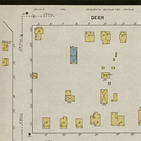
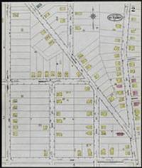
1884-1938. The Sanborn Map Company, the best known of the U.S. fire-insurance map producers, has made maps since 1867. The fire insurance maps produced by San...
2011. Maryland--Anne Arundel County. Anne Arundel County, Maryland is interested in monitoring its changing land use for planning, zoning and environmental protection purposes. The Cou...
1921. Sanborn Map Company. A map of Mt. Rainier, Maryland from January, 1921. The map was created by the Sanborn Map Company from New York and is the second map in a series o...
1921. Sanborn Map Company. A map of Mt. Rainier, Maryland from January 1921. The map was created by the Sanborn Map Company in New York and covers a portion of the town from ...
1911. Sanborn Map Company. Albion, Erie County, Pennsylvania : April 1911. 1 map on 4 sheets : col. ; on sheets 65 x 54 cm. Scale approximately 1:600. 50 ft. to an in. Sanborn Map Company.
1885. Sanborn Map Company. Alburtis, Penna. : Mar. 1885. 1 map : col. ; sheet 64 x 54 cm. Scale approximately 1:600. 50 ft. to an in. Sanborn Map Company.
1911. Sanborn Map Company. Allentown, Pa. [1911]. 1 map on 117 sheets : col. ; sheets 64 x 54 cm. + title sheet, index sheet, and key sheet + 8 ""skeleton"" overlay sheets. O... Sanborn Map Company.
1897. Sanborn Map Company. Allentown, Pa. [1897]. 1 map on 54 sheets : col. ; sheets 65 x 54 cm. + title sheet and key sheet + 18 ""skeleton"" overlay sheets. Title from titl... Sanborn Map Company.
1885. Sanborn Map Company. Allentown, Pa. [1885]. 1 map on 24 sheets : col. ; sheets 64 x 54 cm. + Title sheet (64 x 54 cm.). Title from title sheet; Oriented with north slig... Sanborn Map Company.
1891. Sanborn Map Company. Allentown, Pa. [1891]. 1 map on 31 sheets : col. ; sheets 64 x 54 cm. + Title sheet (64 x 54 cm.). Title from title sheet; Adjoining sheets key on ... Sanborn Map Company.
1906. Sanborn Map Company. Insurance maps of Allegheny including Bellevue and Avalon, Pennsylvania : volume one [and] volume two, 1906. 1 map on 204 sheets : col. ; on sheets... Sanborn Map Company.
1896. Sanborn Map Company. Ambler, Montgomery Co., Pa, June 1896. 1 map on 2 sheets : col. : on sheets 64 x 54 cm.; Publisher's title on sheet 1. Oriented with north sligh... Sanborn Map Company.
1902. Sanborn Map Company. Ambler, Montgomery County, Pennsylvania, May 1902. 1 map on 3 sheets : col. : on sheets 64 x 54 cm.; Publisher's title from sheet 1. Oriented wi... Sanborn Map Company.
1904. Sanborn Map Company. Alliance, Northampton Co., Pennsylvania, Nov. 1904. 1 map on 10 sheets : col. ; sheets 65 x 55 cm. Statement of responsibility: Sanborn Map Company... Sanborn Map Company.
1922. Sanborn Map Company. Allentown, Pa. [1922]. map : col. ; on sheets 64 x 54 cm. Oriented with north slightly to the right; Set follows standard Sanborn color-coding; Map... Sanborn Map Company.
1919. Sanborn Map Company. Allentown, Pa. [1919]. map : col. ; on sheets 64 x 54 cm. Oriented with north slightly to the right; Set follows standard Sanborn color-coding; Map... Sanborn Map Company.
1932. Sanborn Map Company. Insurance maps of Allentown, Pennsylvania. 1 map on 93 sheets : color ; sheets 65 x 55 cm + title sheet (65 x 55 cm) + 2 index sheets (65 x 55 cm)... Sanborn Map Company.
1912. Sanborn Map Company. Aliquippa, Beaver County, Pennsylvania : November 1912. 1 map on 3 sheets : col. ; on sheets 64 x 54 cm.; Title from publisher's label. Oriented w... Sanborn Map Company.
1925. Sanborn Map Company. Aliquippa, Beaver County, Pennsylvania. 1 map on 4 sheets : color ; on sheets 65 x 55 cm. Scale approximately 1:600. 50 ft. to an in. Sanborn Map Company.
1922. Sanborn Map Company. Altoona, Pa. [1922]. maps : col. ; on sheets 65 x 55 cm. July 1922""; Oriented with north to the upper right; Set follow standard Sanborn color-cod... Sanborn Map Company.
1920. Sanborn Map Company. Altoona, Pa. [1920]. maps : col. ; on sheets 65 x 55 cm. Title taken from upper left corner of sheet 99; Oriented with north to the upper right; S... Sanborn Map Company.
1909. Sanborn Map Company. Altoona, Pa. [1909]. 1 map on 100 sheets : col. ; on sheets 64 x 54 cm. Oriented with north to the upper right; ""Corrected to 1909""; Sheet 1 on v... Sanborn Map Company.
1894. Sanborn Map Company. Altoona, Pa. [1894]. 1 map on 41 sheets : col. ; on sheets 65 x 55 cm. + 1 title sheet and 1 key sheet. Oriented with north to the upper right with... Sanborn Map Company.
1888. Sanborn Map Company. Altoona, Pa. [1888]. 1 map on 23 sheets : col. ; on sheets 64 x 54 cm. Oriented with north to the upper right, with some sheets on the horizontal; ... Sanborn Map Company.
1917. Sanborn Map Company. Altoona, Pa. [1917]. 1 map : col. ; on sheet 65 x 55 cm. Jan. 1917""; Oriented with north to the upper right; Set follows standard Sanborn color-co... Sanborn Map Company.
1909. Sanborn Map Company. Ambler, Montgomery County, Pennsylvania, Jan. 1909. 1 map on 13 sheets : col. ; on sheets 64 x 54 cm.; Publisher's title from sheet 1. Oriented ... Sanborn Map Company.
1921. Sanborn Map Company. Ambler : including Fort Washington, Montgomery County, Pennsylvania, Dec. 1921. 1 map on 21 sheets : col. ; on sheets 65 x 55 cm. Publisher's title... Sanborn Map Company.
1905. Sanborn Map Company. Ambridge and Economy, Beaver County, Pennsylvania, Oct. 1905. 1 map on 10 sheets : col. ; sheets 65 x 54 cm. Statement of responsibility: Sanborn M... Sanborn Map Company.
1886. Sanborn Map Company. Apollo, Pa, Feb. 1886. 4 maps on 2 sheets : col. ; on sheets 64 x 54 cm.; Statement of responsibility: Sanborn Map & Publishing Co. Limited. Parti... Sanborn Map Company.
1911. Sanborn Map Company. Annville, Lebanon County, Pennsylvania, Oct. 1911. 1 map on 6 sheets : col. ; on sheets 64 x 54 cm.; Title taken from sheet 1. Oriented with the... Sanborn Map Company.
1902. Sanborn Map Company. Annville, Lebanon Co., Pa, July 1902. 1 map on 4 sheets ; col. ; on sheets 64 x 54 cm.; Title taken from sheet 1. Oriented with north to the upp... Sanborn Map Company.
1895. Sanborn Map Company. Annville, Lebanon Co., Pa, Jan. 1895. 1 map on 4 sheets : col. ; on sheets 64 x 54 cm.; Title taken from sheet 1. Oriented with north to the upper... Sanborn Map Company.
1887. Sanborn Map Company. Annville, PA, Dec. 1887. 1 map on 2 sheets : col. ; on sheets 64 x 54 cm.; Title taken from sheet 1. Oriented with north to the upper right with s... Sanborn Map Company.
1894. Sanborn Map Company. Apollo, Armstrong County, Pa, June 1894. 1 map on 5 sheets : col. ; on sheets 64 x 54 cm. Statement of responsibility: Sanborn-Perris Map Co., Limi... Sanborn Map Company.