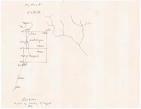
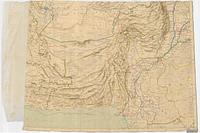
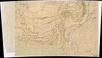
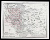
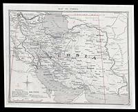
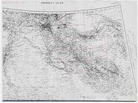
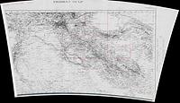
1. Survey of Egypt: Handwritten Key Sheet Syria 1/250,000 Printed by Survey of Egypt 1916
9999. British War Office. British War Office.
9999. British War Office. British War Office.
9999. British War Office. British War Office.
9999. Oxford Center for Maritime Archaeology. Oxford Center for Maritime Archaeology.
9999. Oxford Center for Maritime Archaeology. Oxford Center for Maritime Archaeology.
9999. Oxford Center for Maritime Archaeology. scale listed on back of map. Oxford Center for Maritime Archaeology.
9999. Oxford Center for Maritime Archaeology. Oxford Center for Maritime Archaeology.
9999. Oxford Center for Maritime Archaeology. Oxford Center for Maritime Archaeology.
9999. Oxford Center for Maritime Archaeology. Oxford Center for Maritime Archaeology.
9999. Oxford Center for Maritime Archaeology. Oxford Center for Maritime Archaeology.
9999. Oxford Center for Maritime Archaeology. Oxford Center for Maritime Archaeology.
9999. Oxford Center for Maritime Archaeology. Oxford Center for Maritime Archaeology.
9999. Oxford Center for Maritime Archaeology. Oxford Center for Maritime Archaeology.
9999. Oxford Center for Maritime Archaeology. Oxford Center for Maritime Archaeology.
9999. Oxford Center for Maritime Archaeology. Oxford Center for Maritime Archaeology.
9999. Oxford Center for Maritime Archaeology. Enlarged from War Office Map 2209 Front and Back Paper Tears at the seams. Oxford Center for Maritime Archaeology.
9999. Oxford Center for Maritime Archaeology. Enlarged from War Office Map 2209 Front and Back Paper Tears at the seams. Oxford Center for Maritime Archaeology.
2081-2100. Dr. Eric Compas, University of Wisconsin-Whitewater. This raster dataset contains a simplified version of the probabilistic downscaled climate modeling data produced by the Wisconsin Initiative on Cli...
2081-2100. Dr. Eric Compas, University of Wisconsin-Whitewater. This raster dataset contains a simplified version of the probabilistic downscaled climate modeling data produced by the Wisconsin Initiative on Cli...
2081-2100. Dr. Eric Compas, University of Wisconsin-Whitewater. This raster dataset contains a simplified version of the probabilistic downscaled climate modeling data produced by the Wisconsin Initiative on Cli...
2081-2100. Dr. Eric Compas, University of Wisconsin-Whitewater. This raster dataset contains a simplified version of the probabilistic downscaled climate modeling data produced by the Wisconsin Initiative on Cli...
2080. Baltimore County Government. A 2014 Digital Elevation Model (cell size equal to 2.5 ft by 2.5 ft) was used to identify continuous coastal land areas with elevations less than 3...
2080. Baltimore County Government. The Stormwater Network consists of 11 features classes with related drawing number tables. Feature classes include: inflow points, outfall points, ...
2080. Baltimore County Government. The Stormwater Network consists of 11 features classes with related drawing number tables. Feature classes include: inflow points, outfall points, ...
2080. Department of the Interior. Hosted feature layer to be consumed by the "Can We Conserve Wetlands Under a Changing Climate?" story map. As the impacts of climate change amplify...
2080. Department of the Interior. Hosted feature layer to be consumed by the "Can We Conserve Wetlands Under a Changing Climate?" story map. As the impacts of climate change amplify...
2080. Department of the Interior. Hosted feature layer to be consumed by the "Can We Conserve Wetlands Under a Changing Climate?" story map. As the impacts of climate change amplify...
2080. Department of the Interior. inundation at 2080 from - Lentz, E.E., Thieler, E.R., Plant, N.G., Stippa, S.R., Horton, R., and Gesch, D., 2016, Evaluation of dynamic coastal res...
2080. Department of the Interior. THESE DATA ARE BEING REPLACED IN 2022. These data show the priority deficit and surplus HUC12 watersheds for wetland restoration/enhancement or pro...
2072. Polk County. Aerial imagery for Polk County captured in 2019 by EagleView Pictometry.
2070. Department of the Interior. NWI Wetlands in West Virginia (HU8 02070001) to be displayed in a story map for the Advanced Water Mapping Analytics (AWMA) working group.The AWMA ...
2070. ArcGIS Online for Maryland. This dataset visualizes the projected areas that will be flooded/drowned by 2070. Within the Sea-Level Affecting Marshes Model (SLAMM), it is proje...
2070. ArcGIS Online for Maryland. SLAMM uses elevation, accumulation of sediments, wetland accretion and erosion rates, and sea level rise to predicatively model long-term wetland a...
2070. ArcGIS Online for Maryland. Within the Sea-Level Affecting Marshes Model (SLAMM) , it is projected that Maryland's coastal waters will rise 2.32 feet by 2070 under a scenario ...
2070. Department of the Interior. This dataset contains a representation of 2010 developed lands used in the Florida 2070 project. Florida 2070 and its companion project Water 2070 ...
2070. Department of the Interior. NWI Wetlands in West Virginia (HU8 02070001) to be displayed in a story map for the Advanced Water Mapping Analytics (AWMA) working group.The AWMA ...
2062. Lorain County Auditor GIS. Flight flown April 2020 by Eagleview. Pixel resolution is 2".Tile Projection:CoordSys: US State Plane 1983CoordDatum: North American Datum 1983Coor...
2062. Lorain County Auditor GIS. Flight flown April 2020 by Eagleview. Pixel resolution is 2".Tile Projection:CoordSys: US State Plane 1983CoordDatum: North American Datum 1983Coor...
2062. Lorain County Auditor GIS. Flight flown April 2022 by Eagleview. Pixel resolution is 2".Tile Projection:CoordSys: US State Plane 1983CoordDatum: North American Datum 1983Coor...
2062. Lorain County Auditor GIS. Flight flown April 2020 by Eagleview. Pixel resolution is 2".Tile Projection:CoordSys: US State Plane 1983CoordDatum: North American Datum 1983Coor...
2061-2080. Dr. Eric Compas, University of Wisconsin-Whitewater. This raster dataset contains a simplified version of the probabilistic downscaled climate modeling data produced by the Wisconsin Initiative on Cli...
2061-2080. Dr. Eric Compas, University of Wisconsin-Whitewater. This raster dataset contains a simplified version of the probabilistic downscaled climate modeling data produced by the Wisconsin Initiative on Cli...
2061-2080. Dr. Eric Compas, University of Wisconsin-Whitewater. This raster dataset contains a simplified version of the probabilistic downscaled climate modeling data produced by the Wisconsin Initiative on Cli...
2061-2080. Dr. Eric Compas, University of Wisconsin-Whitewater. This raster dataset contains a simplified version of the probabilistic downscaled climate modeling data produced by the Wisconsin Initiative on Cli...
2060. Department of the Interior. Coastal wetlands along the Gulf of Mexico support a wide diversity of wildlife, are important nurseries for sport and commercial fisheries, provide...
2050. Baltimore County Government. A 2014 Digital Elevation Model (cell size equal to 2.5 ft by 2.5 ft) was used to identify continuous coastal land areas with elevations less than 2...
2050. Baltimore County Government. The Stormwater Network consists of 11 features classes with related drawing number tables. Feature classes include: inflow points, outfall points, ...
2050. Baltimore County Government. The Stormwater Network consists of 11 features classes with related drawing number tables. Feature classes include: inflow points, outfall points, ...
2050. DVRPC-GIS. As a part of DVRPC's long-range planning activities, the Commission is required to maintain forecasts with at least a 20-year horizon, or to the ho...
2050. Environmental Resilience Institute. Total projected annual average number of hot days and uncomfortable nights per Indiana county for year 2050, high emissions scenario (RCP 8.5).
2050. Environmental Resilience Institute. Total projected annual average number of hot days and uncomfortable nights per Indiana county for year 2050, medium emissions scenario (RCP 4.5).