1. ArcGIS Living Atlas of the World

Living Atlas is a centralized platform where Esri offers authoritative, curated, and ready-to-use content can be utilized by the GIS community. Esri.
Living Atlas is a centralized platform where Esri offers authoritative, curated, and ready-to-use content can be utilized by the GIS community. Esri.

2000-present. Data.census.gov is the centralized platform to access data and digital content from the U.S. Census Bureau. U.S. Census Bureau.

2000-present. The Living Atlas collection features census records derived from the U.S. Census Bureau. These datasets are available as geospatial web services an... Esri.
1502. France. Comité des travaux historiques et scientifiques and Mappemonde Portugaise anonyme de 1502. Trs lgrement rduite. From Bulletin de geographie historique et descriptive, v. 1, 1886. Map is opp. p. 382. Discussion of map, p. 147-160. 1 map; 8...
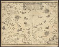
1598. Barentsz, Willem, approximately 1550-1597, Claesz, Cornelis, approximately 1546-1609, and Duetecum, Baptista. 1 map; 42 x 57 cm.
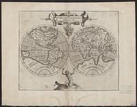
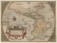
1597?. Wytfliet, Corneille. Relief shown pictorially. From: "Descriptionis Ptolemaicae Augmentum". 1 map; 2 hemispheres each 14 cm. diam., on sheet 30 x 38 cm.
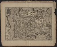
between 1597 and 1634. Bogard, Jean, -approximately 1634, Dahl, James, former owner, and Wytfliet, Corneille. Relief shown pictorially. North oriented to the left of the map. Shows drainage and settlements pictorially. 1 map; 22 x 27 cm.
1570?. Ortelius, Abraham, 1527-1598. Relief shown pictorially. On verso: Text and plate number "2." Appeared as pl. 2 in his Theatrum orbis terrarum. Antwerp, 1570. Decorative cartouch...
1621. Janssonius van Waesberge, Johannes, active 1642-1681. Relief shown pictorially. Map is oriented with North to the right. Vignette in lower right corner shows three portraits of royalty and two birds wi...
Magini, Giovanni Antonio, 1555-1617. 1 map ; 5 x 7 in. Relief shown pictorially. Signature "Ll iij La". Page number 201 from "Geografia de Cl. Tolomeo.".
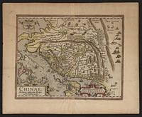
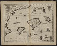
1584. Barbuda, Luis Jorge de, fl. 1575-1599 and Ortelius, Abraham, 1527-1598. Relief shown pictorially. Oriented with north to the right. Includes ill. and decorative cartouches. On verso: La China, p. 118. From Ortellius' Th...
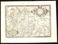
Hondius, Hendrik, 1597-1651, Jansson, Jan, 1588-1664. Atlantis Maioris Appendix, 1630, and Vignaud, Henry, 1830-1922, former owner. 2 maps on 1 sheet ; sheet 45 x 57 cm Relief shown pictorially. North oriented to the top on top map; north oriented to the top right corner on bott...
![[Europe as a woman].](https://geo.btaa.org/rails/active_storage/representations/redirect/eyJfcmFpbHMiOnsibWVzc2FnZSI6IkJBaHBBdHhmIiwiZXhwIjpudWxsLCJwdXIiOiJibG9iX2lkIn19--ee8b9003e42e41a34a3683af01f01f0008347bad/eyJfcmFpbHMiOnsibWVzc2FnZSI6IkJBaDdCem9MWm05eWJXRjBTU0lKYW5CbFp3WTZCa1ZVT2hKeVpYTnBlbVZmZEc5ZlptbDBXd2RwQWNndyIsImV4cCI6bnVsbCwicHVyIjoidmFyaWF0aW9uIn19--fb19b03b9eb4e78013d4cfb2b84169f3537e0279/a222b3ef-8d0b-4d77-85b0-65bfc23b5369.jpeg)
1550. Putsch, Johann. Map of Europe in the form of a woman, with her head facing Africa and labled as Hispania and the bottom of the woman's dress labled as Greece, Bulg...
1564. Le Moyne de Morgues, Jacques, 1533?-1588. To accompany Le Moyne's narrative 979 F6L. Reproduction, probably late 19th cent. 1 map; 37 x 46 cm.
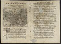
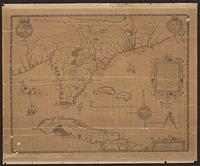
1597. Dahl, James, former owner and Wytfliet, Corneille. Relief shown pictorially. Shows southeastern states plus part of Cuba and Bahamas. Watermark. Included in Wytfliet's "Descriptionis Ptolemaicae Aug...
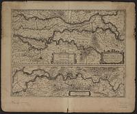
1616. London Topographical Society and Visscher, Claes Jansz., 1586 or 1587-1652. Alternate title: View of London by C. J. Visscher, A.D. 1616. Title from title sheet: View of London, A.D. 1616. By Nicholas John Visscher. "A facs...
between 1600 and 1680. Hamersveldt, Everard Symonsz, 1591-1653, engraver, Jansson, Jan, 1588-1664. Appendix Atlas, and Vignaud, Henry, 1830-1922, former owner. 1 map ; 38 x 48 cm. Relief shown pictorially. Includes coats of arms and illustrations of ships and sea monsters in the ocean. This state was publi...
1584. Dahl, James, former owner, Ortelius, Abraham, 1527-1598, and Plantin, Christophe, approximately 1520-1589, printer. This is map no. 92 of the author's Theatrvm orbis terrarvm. Antwerpiae, 1584. Cf. U.S. Library of Congress. Division of Maps. A list of geographica...
1630. Jansson, Jan, 1588-1664, Jansson, Jan, 1588-1664. Atlantis Maioris Appendix, 1630, Keere, Pieter van den, 1571-approximately 1646, and Vignaud, Henry, 1830-1922, former owner. Relief shown pictorially. Includes a dedication to Iacobus Monavius Silesius patricius by Abraham Ortelius. From "Atlantis maioris appendix", Johan...
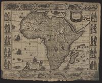
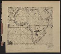
1630. Hondius, Jodocus, 1594 or 1595-1629, cartographer, Jansson, Jan, 1588-1664, Jansson, Jan, 1588-1664. Atlantis Maioris Appendix, 1630, and Vignaud, Henry, 1830-1922, former owner. Relief shown pictorially. Border includes views of 12 African cities and examples of local costumes, while the map includes illustrations of flying...