1. Future Land Use and Built Form [Minnesota--Minneapolis] {2040}
2040. MapIT Minneapolis. For questions about this data please contactCPEDOpenData@minneapolismn.govThe Future Land Use and Built Form Maps are the primary tools for impleme...
2040. MapIT Minneapolis. For questions about this data please contactCPEDOpenData@minneapolismn.govThe Future Land Use and Built Form Maps are the primary tools for impleme...
![Metropolitan Urban Service Areas (MUSA) Composite [Minnesota]](https://geo.btaa.org/rails/active_storage/representations/redirect/eyJfcmFpbHMiOnsibWVzc2FnZSI6IkJBaHBBaFdXIiwiZXhwIjpudWxsLCJwdXIiOiJibG9iX2lkIn19--aff95d9a14879dcfe505de79fd4665a571b4df3d/eyJfcmFpbHMiOnsibWVzc2FnZSI6IkJBaDdCem9MWm05eWJXRjBTU0lKYW5CbFp3WTZCa1ZVT2hKeVpYTnBlbVZmZEc5ZlptbDBXd2RwQWNndyIsImV4cCI6bnVsbCwicHVyIjoidmFyaWF0aW9uIn19--fb19b03b9eb4e78013d4cfb2b84169f3537e0279/3fd08f21-f937-4b7d-b89a-3c7dfd0f15f3.jpeg)
2024-01-19. Metropolitan Council of the Twin Cities Area. The MUSA Composite dataset depicts current and future boundaries of the Urban Service Areas (sewer service areas) based on communities' comprehensi...
2024-01-19. Metropolitan Council of the Twin Cities Area. The ThriveMSP 2040 Community Designations was adopted on May 28, 2014. This dataset reflects the agreed upon community designation between a commun...
2022-09-01. Metropolitan Council of the Twin Cities Area. High resolution (10 meter) land surface temperature (LST) from September 1, 2022 is mapped for the seven-county metropolitan region of the Twin Cit...
2020-04-10. Metropolitan Council of the Twin Cities Area. The 2020 Generalized Land Use Inventory dataset encompasses the seven county Twin Cities (Minneapolis and St. Paul) Metropolitan Area in Minnesota....
![Generalized Land Use Historical (1984, 1990, 1997, 2000, 2005, 2010, 2016, 2020) [Minnesota]](https://geo.btaa.org/rails/active_storage/representations/redirect/eyJfcmFpbHMiOnsibWVzc2FnZSI6IkJBaHBBbGlMIiwiZXhwIjpudWxsLCJwdXIiOiJibG9iX2lkIn19--c071cbdf309246cc37e9d4f13f25352e274c33b9/eyJfcmFpbHMiOnsibWVzc2FnZSI6IkJBaDdCem9MWm05eWJXRjBTU0lKYW5CbFp3WTZCa1ZVT2hKeVpYTnBlbVZmZEc5ZlptbDBXd2RwQWNndyIsImV4cCI6bnVsbCwicHVyIjoidmFyaWF0aW9uIn19--fb19b03b9eb4e78013d4cfb2b84169f3537e0279/15a50230-0245-41ae-b6fd-fbb2ebc06ba7.jpeg)
2020-04-10. Metropolitan Council of the Twin Cities Area. The Historical Generalized Land Use dataset encompasses the seven county Twin Cities (Minneapolis and St. Paul) Metropolitan Area in Minnesota. The...
2020. MapIT Minneapolis. For questions about this data please contact311OpenData@minneapolismn.govThe data provided are public-facing service requests that were taken by 31...
2019. MapIT Minneapolis. For questions about this data please contact311OpenData@minneapolismn.gov The data provided are public-facing service requests that were taken by 3...
2018. MapIT Minneapolis. For questions about this data please contact311OpenData@minneapolismn.gov The data provided are public-facing service requests that were taken by 3...
2017. MapIT Minneapolis. For questions about this data please contact311OpenData@minneapolismn.gov The data provided are public-facing service requests that were taken by 3...
![Generalized Land Use 2016 [Minnesota]](https://geo.btaa.org/rails/active_storage/representations/redirect/eyJfcmFpbHMiOnsibWVzc2FnZSI6IkJBaHBBbHlMIiwiZXhwIjpudWxsLCJwdXIiOiJibG9iX2lkIn19--63535dcb501ef0b3153d1fe1b48b8f5cf2a86bdd/eyJfcmFpbHMiOnsibWVzc2FnZSI6IkJBaDdCem9MWm05eWJXRjBTU0lKYW5CbFp3WTZCa1ZVT2hKeVpYTnBlbVZmZEc5ZlptbDBXd2RwQWNndyIsImV4cCI6bnVsbCwicHVyIjoidmFyaWF0aW9uIn19--fb19b03b9eb4e78013d4cfb2b84169f3537e0279/249d522a-1f68-4714-8160-a8948df939f6.jpeg)
2016-04-22. Metropolitan Council of the Twin Cities Area. The 2016 Generalized Land Use Inventory dataset encompasses the seven county Twin Cities (Minneapolis and St. Paul) Metropolitan Area in Minnesota....
2016-07-22. Metropolitan Council of the Twin Cities Area. The Land Surface Temperature (LST) raster dataset is a dataset derived from a satellite image from Landsat 8 to show the land surface temperature f...
2016. MapIT Minneapolis. For questions about this data please contact311OpenData@minneapolismn.gov The data provided are public-facing service requests that were taken by 3...
2015. MapIT Minneapolis. For questions about this data please contact311OpenData@minneapolismn.govThe data provided are public-facing service requests that were taken by 31...
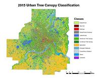
2015. Host, Trevor K., Knight, Joe F., and Rampi, Lian P. A high-resolution (1-meter) tree canopy assessment was completed for the Twin Cities Metropolitan Area. Mapping of existing and potential tree cano...
![2030 Regional Development Framework Planning Areas 2011 [Minnesota]](https://geo.btaa.org/rails/active_storage/representations/redirect/eyJfcmFpbHMiOnsibWVzc2FnZSI6IkJBaHBBZ0p0IiwiZXhwIjpudWxsLCJwdXIiOiJibG9iX2lkIn19--acaa87c7dabf9c6baaec0028a0bc6e48e3e02731/eyJfcmFpbHMiOnsibWVzc2FnZSI6IkJBaDdCem9MWm05eWJXRjBTU0lKYW5CbFp3WTZCa1ZVT2hKeVpYTnBlbVZmZEc5ZlptbDBXd2RwQWNndyIsImV4cCI6bnVsbCwicHVyIjoidmFyaWF0aW9uIn19--fb19b03b9eb4e78013d4cfb2b84169f3537e0279/02236876-9c21-42f6-9870-d2562da8e44f.jpeg)
2014-05-23. Metropolitan Council of the Twin Cities Area. The 2030 Regional Development Framework Planning Areas - 2011 updates the 2030 Regional Development Framework Planning Areas initially adopted on J...
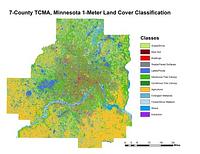
2011-2015. Host, Trevor K., Knight, Joe F., and Rampi, Lian P. A high-resolution (1-meter) land cover classification raster dataset was completed for three different geographic areas in Minnesota: Duluth, Roche... Remote Sensing and Geospatial Analysis Laboratory.
![Generalized Land Use 2010 [Minnesota]](https://geo.btaa.org/rails/active_storage/representations/redirect/eyJfcmFpbHMiOnsibWVzc2FnZSI6IkJBaHBBbHVMIiwiZXhwIjpudWxsLCJwdXIiOiJibG9iX2lkIn19--dde841b25d7e88886ab0f21dcc33df1ff5701cf9/eyJfcmFpbHMiOnsibWVzc2FnZSI6IkJBaDdCem9MWm05eWJXRjBTU0lKYW5CbFp3WTZCa1ZVT2hKeVpYTnBlbVZmZEc5ZlptbDBXd2RwQWNndyIsImV4cCI6bnVsbCwicHVyIjoidmFyaWF0aW9uIn19--fb19b03b9eb4e78013d4cfb2b84169f3537e0279/5c531877-7ab8-4a03-8080-6c59440561d1.jpeg)
2010-04-20. Metropolitan Council of the Twin Cities Area. The 2010 Generalized Land Use Inventory dataset encompasses the seven county Twin Cities (Minneapolis and St. Paul) Metropolitan Area in Minnesota....
2008-04-23. U.S. Geological Survey (USGS). This dataset consists of 0.3-meter pixel resolution (approximately 1-foot), natural color orthoimages covering the Minneapolis-St. Paul urban area ...
![Bikeways [Minnesota]](https://geo.btaa.org/rails/active_storage/representations/redirect/eyJfcmFpbHMiOnsibWVzc2FnZSI6IkJBaHBBdTV3IiwiZXhwIjpudWxsLCJwdXIiOiJibG9iX2lkIn19--6b4dfac6cb3285ebb5a52574a981e0ca3b121fdc/eyJfcmFpbHMiOnsibWVzc2FnZSI6IkJBaDdCem9MWm05eWJXRjBTU0lKYW5CbFp3WTZCa1ZVT2hKeVpYTnBlbVZmZEc5ZlptbDBXd2RwQWNndyIsImV4cCI6bnVsbCwicHVyIjoidmFyaWF0aW9uIn19--fb19b03b9eb4e78013d4cfb2b84169f3537e0279/b83d0f73-a44a-43a5-a108-f029215e635c.jpeg)
2007-04-06. Minnesota Department of Transportation (MNDOT). The regional bikeways dataset was created by the Minnesota Dept of Transportation (MNDOT) in 2003. It has been maintained and updated by the Land M...