1. 1-Foot Contours, Burnsville [Minnesota--Dakota County]
![1-Foot Contours, Burnsville [Minnesota--Dakota County]](https://geo.btaa.org/rails/active_storage/representations/redirect/eyJfcmFpbHMiOnsibWVzc2FnZSI6IkJBaHBBdmhzIiwiZXhwIjpudWxsLCJwdXIiOiJibG9iX2lkIn19--3ae274a51f8984aef6b81f33594b3dc821c73a47/eyJfcmFpbHMiOnsibWVzc2FnZSI6IkJBaDdCem9MWm05eWJXRjBTU0lKYW5CbFp3WTZCa1ZVT2hKeVpYTnBlbVZmZEc5ZlptbDBXd2RwQWNndyIsImV4cCI6bnVsbCwicHVyIjoidmFyaWF0aW9uIn19--fb19b03b9eb4e78013d4cfb2b84169f3537e0279/4f370ad1-038f-4c47-91ef-89740d98ed28.jpeg)
Minnesota--Dakota County. Fugro Horizons Inc. acquired highly accurate Light Detection and Ranging (LiDAR) elevation data for the Twin Cities metropolitan region in east-cen...
Minnesota--Dakota County. Fugro Horizons Inc. acquired highly accurate Light Detection and Ranging (LiDAR) elevation data for the Twin Cities metropolitan region in east-cen...
![1-Foot Contours, Eagan [Minnesota--Dakota County]](https://geo.btaa.org/rails/active_storage/representations/redirect/eyJfcmFpbHMiOnsibWVzc2FnZSI6IkJBaHBBdmxzIiwiZXhwIjpudWxsLCJwdXIiOiJibG9iX2lkIn19--9d0eeca808288166719099036cd51a4b3baae91b/eyJfcmFpbHMiOnsibWVzc2FnZSI6IkJBaDdCem9MWm05eWJXRjBTU0lKYW5CbFp3WTZCa1ZVT2hKeVpYTnBlbVZmZEc5ZlptbDBXd2RwQWNndyIsImV4cCI6bnVsbCwicHVyIjoidmFyaWF0aW9uIn19--fb19b03b9eb4e78013d4cfb2b84169f3537e0279/95e9a1cb-ebf0-42b5-9311-d55c729d2aad.jpeg)
Minnesota--Dakota County. Fugro Horizons Inc. acquired highly accurate Light Detection and Ranging (LiDAR) elevation data for the Twin Cities metropolitan region in east-cen...
![1-Foot Contours, Apple Valley [Minnesota--Dakota County]](https://geo.btaa.org/rails/active_storage/representations/redirect/eyJfcmFpbHMiOnsibWVzc2FnZSI6IkJBaHBBdmRzIiwiZXhwIjpudWxsLCJwdXIiOiJibG9iX2lkIn19--6bc7643f2e7ef9605555a3116c64f3c71a679341/eyJfcmFpbHMiOnsibWVzc2FnZSI6IkJBaDdCem9MWm05eWJXRjBTU0lKYW5CbFp3WTZCa1ZVT2hKeVpYTnBlbVZmZEc5ZlptbDBXd2RwQWNndyIsImV4cCI6bnVsbCwicHVyIjoidmFyaWF0aW9uIn19--fb19b03b9eb4e78013d4cfb2b84169f3537e0279/26287ad9-7d76-4bce-b775-0bf192ac4f19.jpeg)
Minnesota--Dakota County. Fugro Horizons Inc. acquired highly accurate Light Detection and Ranging (LiDAR) elevation data for the Twin Cities metropolitan region in east-cen...
![1-Foot Contours, Inver Grove Heights [Minnesota--Dakota County]](https://geo.btaa.org/rails/active_storage/representations/redirect/eyJfcmFpbHMiOnsibWVzc2FnZSI6IkJBaHBBdnRzIiwiZXhwIjpudWxsLCJwdXIiOiJibG9iX2lkIn19--603f523fbef33e361341e389a6337d7e47569cf2/eyJfcmFpbHMiOnsibWVzc2FnZSI6IkJBaDdCem9MWm05eWJXRjBTU0lKYW5CbFp3WTZCa1ZVT2hKeVpYTnBlbVZmZEc5ZlptbDBXd2RwQWNndyIsImV4cCI6bnVsbCwicHVyIjoidmFyaWF0aW9uIn19--fb19b03b9eb4e78013d4cfb2b84169f3537e0279/bef15d54-e213-4441-97b8-b0f8244d67cf.jpeg)
Minnesota--Dakota County. Fugro Horizons Inc. acquired highly accurate Light Detection and Ranging (LiDAR) elevation data for the Twin Cities metropolitan region in east-cen...
![1-Foot Contours, Farmington [Minnesota--Dakota County]](https://geo.btaa.org/rails/active_storage/representations/redirect/eyJfcmFpbHMiOnsibWVzc2FnZSI6IkJBaHBBdnBzIiwiZXhwIjpudWxsLCJwdXIiOiJibG9iX2lkIn19--b5005951425b1bfcea67ad29c4bec3199be50e19/eyJfcmFpbHMiOnsibWVzc2FnZSI6IkJBaDdCem9MWm05eWJXRjBTU0lKYW5CbFp3WTZCa1ZVT2hKeVpYTnBlbVZmZEc5ZlptbDBXd2RwQWNndyIsImV4cCI6bnVsbCwicHVyIjoidmFyaWF0aW9uIn19--fb19b03b9eb4e78013d4cfb2b84169f3537e0279/5479f6be-b8e0-445d-995e-2b9a04189937.jpeg)
Minnesota--Dakota County. Fugro Horizons Inc. acquired highly accurate Light Detection and Ranging (LiDAR) elevation data for the Twin Cities metropolitan region in east-cen...
![1-Foot Contours, Rosemount [Minnesota--Dakota County]](https://geo.btaa.org/rails/active_storage/representations/redirect/eyJfcmFpbHMiOnsibWVzc2FnZSI6IkJBaHBBdjFzIiwiZXhwIjpudWxsLCJwdXIiOiJibG9iX2lkIn19--b21bcf2cb6084c60b9095ded84bac0d5fb4c337b/eyJfcmFpbHMiOnsibWVzc2FnZSI6IkJBaDdCem9MWm05eWJXRjBTU0lKYW5CbFp3WTZCa1ZVT2hKeVpYTnBlbVZmZEc5ZlptbDBXd2RwQWNndyIsImV4cCI6bnVsbCwicHVyIjoidmFyaWF0aW9uIn19--fb19b03b9eb4e78013d4cfb2b84169f3537e0279/ac495b7c-9243-4087-9cd9-69e0f1562673.jpeg)
Minnesota--Dakota County. Fugro Horizons Inc. acquired highly accurate Light Detection and Ranging (LiDAR) elevation data for the Twin Cities metropolitan region in east-cen...
![1-Foot Contours, West St Paul [Minnesota--Dakota County]](https://geo.btaa.org/rails/active_storage/representations/redirect/eyJfcmFpbHMiOnsibWVzc2FnZSI6IkJBaHBBdjlzIiwiZXhwIjpudWxsLCJwdXIiOiJibG9iX2lkIn19--f0feb29c979540b692aa472fd9c14684584ea948/eyJfcmFpbHMiOnsibWVzc2FnZSI6IkJBaDdCem9MWm05eWJXRjBTU0lKYW5CbFp3WTZCa1ZVT2hKeVpYTnBlbVZmZEc5ZlptbDBXd2RwQWNndyIsImV4cCI6bnVsbCwicHVyIjoidmFyaWF0aW9uIn19--fb19b03b9eb4e78013d4cfb2b84169f3537e0279/eaa0f485-18ae-4dbd-ab2a-91f112f23fdc.jpeg)
Minnesota--Dakota County. Fugro Horizons Inc. acquired highly accurate Light Detection and Ranging (LiDAR) elevation data for the Twin Cities metropolitan region in east-cen...
![1-Foot Contours, South St Paul [Minnesota--Dakota County]](https://geo.btaa.org/rails/active_storage/representations/redirect/eyJfcmFpbHMiOnsibWVzc2FnZSI6IkJBaHBBdjVzIiwiZXhwIjpudWxsLCJwdXIiOiJibG9iX2lkIn19--0ba2b040abbbc407d8dde021179f05a31e0353d9/eyJfcmFpbHMiOnsibWVzc2FnZSI6IkJBaDdCem9MWm05eWJXRjBTU0lKYW5CbFp3WTZCa1ZVT2hKeVpYTnBlbVZmZEc5ZlptbDBXd2RwQWNndyIsImV4cCI6bnVsbCwicHVyIjoidmFyaWF0aW9uIn19--fb19b03b9eb4e78013d4cfb2b84169f3537e0279/e840be7c-d2ab-4011-8e73-05e7cee5beb1.jpeg)
Minnesota--Dakota County. Fugro Horizons Inc. acquired highly accurate Light Detection and Ranging (LiDAR) elevation data for the Twin Cities metropolitan region in east-cen...
![1-Foot Contours, Mendota Heights [Minnesota--Dakota County]](https://geo.btaa.org/rails/active_storage/representations/redirect/eyJfcmFpbHMiOnsibWVzc2FnZSI6IkJBaHBBdnhzIiwiZXhwIjpudWxsLCJwdXIiOiJibG9iX2lkIn19--4e715f0800cae8e03515996bc7f29287a10e5a27/eyJfcmFpbHMiOnsibWVzc2FnZSI6IkJBaDdCem9MWm05eWJXRjBTU0lKYW5CbFp3WTZCa1ZVT2hKeVpYTnBlbVZmZEc5ZlptbDBXd2RwQWNndyIsImV4cCI6bnVsbCwicHVyIjoidmFyaWF0aW9uIn19--fb19b03b9eb4e78013d4cfb2b84169f3537e0279/50191afd-9f5f-418a-8bc8-8ebcb38e4175.jpeg)
Minnesota--Dakota County. Fugro Horizons Inc. acquired highly accurate Light Detection and Ranging (LiDAR) elevation data for the Twin Cities metropolitan region in east-cen...
Metropolitan Council and the U.S. Census Bureau. Summary File 3 Data Profile 3 (SF3 Table DP-3) for Minneapolis-St. Paul 7 County metropolitan area is a subset of the profile of selected economic ...
Metropolitan Council and the U.S. Census Bureau. Summary File 3 Data Profile 2 (SF3 Table DP-2) for Census Tracts in Minneapolis-St. Paul 7 County metropolitan area is a subset of the profile of s...
Metropolitan Council and the U.S. Census Bureau. Summary File 1 Data Profile 1 (SF1 Table DP-1) for Census Tracts in the Minneapolis-St. Paul 7 County metropolitan area is a subset of the profile ...
Metropolitan Council and the U.S. Census Bureau. Summary File 3 Data Profile 4 (SF3 Table DP-4) for Census Tracts in the Minneapolis-St. Paul 7 County metropolitan area is a subset of the profile ...
![Racial Covenants [Hennepin County, Minnesota] (1910-1955)](https://geo.btaa.org/rails/active_storage/representations/redirect/eyJfcmFpbHMiOnsibWVzc2FnZSI6IkJBaHBBZ05wIiwiZXhwIjpudWxsLCJwdXIiOiJibG9iX2lkIn19--6b92ffee4333718a6c6e2f09654bbde875876e28/eyJfcmFpbHMiOnsibWVzc2FnZSI6IkJBaDdCem9MWm05eWJXRjBTU0lKYW5CbFp3WTZCa1ZVT2hKeVpYTnBlbVZmZEc5ZlptbDBXd2RwQWNndyIsImV4cCI6bnVsbCwicHVyIjoidmFyaWF0aW9uIn19--fb19b03b9eb4e78013d4cfb2b84169f3537e0279/0455d309-e4e9-473e-8c3f-b42a6a2e16fc.jpeg)
1910-1955. Delegard, Kirsten, Ehrman-Solberg, Kevin, Mattke, Ryan, Mills, Marguerite, and Petersen, Penny. This data was compiled by the Mapping Prejudice Project and shows the location of racial covenants recorded in Hennepin County between 1910 and 195... University of Minnesota Mapping Prejudice Project.
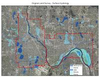
1848-1858. Graves, Richard (Professor of architecture), Kernik, Melinda, Kne, Len, Mattke, Ryan, Shepard, Coleman, and Strong, Richard (Professor of architecture). These shapefiles of lakes, streams, wetlands, river bottoms, and the Mississippi River represent the hydrological landscape of Minneapolis and St. ...
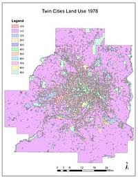
1978. Chen, Wei and Levinson, David M. High-quality GIS land use maps for the Twin Cities Metropolitan Area for 1978 that were developed from paper maps (no GIS version existed previousl...
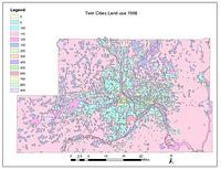
1968. Chen, Wei and Levinson, David M. High-quality GIS land use maps for the Twin Cities Metropolitan Area for 1968 that were developed from paper maps (no GIS version existed previousl...
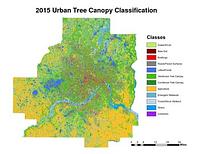
2015. Host, Trevor K., Knight, Joe F., and Rampi, Lian P. A high-resolution (1-meter) tree canopy assessment was completed for the Twin Cities Metropolitan Area. Mapping of existing and potential tree cano...
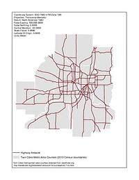
1920-1995. Chen, Wei and Levinson, David M. Illustrates the development of the highway network in the Twin Cities metropolitan region. GIS maps of the state highway network were created for 1...
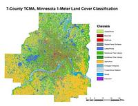
2011-2015. Host, Trevor K., Knight, Joe F., and Rampi, Lian P. A high-resolution (1-meter) land cover classification raster dataset was completed for three different geographic areas in Minnesota: Duluth, Roche... Remote Sensing and Geospatial Analysis Laboratory.