1. Future Land Use and Built Form [Minnesota--Minneapolis] {2040}
2040. MapIT Minneapolis. For questions about this data please contactCPEDOpenData@minneapolismn.govThe Future Land Use and Built Form Maps are the primary tools for impleme...
2040. MapIT Minneapolis. For questions about this data please contactCPEDOpenData@minneapolismn.govThe Future Land Use and Built Form Maps are the primary tools for impleme...
![Generalized Land Use 2005 [Minnesota]](https://geo.btaa.org/rails/active_storage/representations/redirect/eyJfcmFpbHMiOnsibWVzc2FnZSI6IkJBaHBBbHFMIiwiZXhwIjpudWxsLCJwdXIiOiJibG9iX2lkIn19--c8756a9879899490adab298de6e8279f733552fc/eyJfcmFpbHMiOnsibWVzc2FnZSI6IkJBaDdCem9MWm05eWJXRjBTU0lKYW5CbFp3WTZCa1ZVT2hKeVpYTnBlbVZmZEc5ZlptbDBXd2RwQWNndyIsImV4cCI6bnVsbCwicHVyIjoidmFyaWF0aW9uIn19--fb19b03b9eb4e78013d4cfb2b84169f3537e0279/8eb314dc-9a4e-4d8c-999e-6fdcf401c663.jpeg)
2005-04-14. Metropolitan Council of the Twin Cities Area. The 2005 Generalized Land Use dataset encompasses the seven county Twin Cities (Minneapolis and St. Paul) Metropolitan Area in Minnesota. The data...
![Generalized Land Use 2016 [Minnesota]](https://geo.btaa.org/rails/active_storage/representations/redirect/eyJfcmFpbHMiOnsibWVzc2FnZSI6IkJBaHBBbHlMIiwiZXhwIjpudWxsLCJwdXIiOiJibG9iX2lkIn19--63535dcb501ef0b3153d1fe1b48b8f5cf2a86bdd/eyJfcmFpbHMiOnsibWVzc2FnZSI6IkJBaDdCem9MWm05eWJXRjBTU0lKYW5CbFp3WTZCa1ZVT2hKeVpYTnBlbVZmZEc5ZlptbDBXd2RwQWNndyIsImV4cCI6bnVsbCwicHVyIjoidmFyaWF0aW9uIn19--fb19b03b9eb4e78013d4cfb2b84169f3537e0279/249d522a-1f68-4714-8160-a8948df939f6.jpeg)
2016-04-22. Metropolitan Council of the Twin Cities Area. The 2016 Generalized Land Use Inventory dataset encompasses the seven county Twin Cities (Minneapolis and St. Paul) Metropolitan Area in Minnesota....
2020-04-10. Metropolitan Council of the Twin Cities Area. The 2020 Generalized Land Use Inventory dataset encompasses the seven county Twin Cities (Minneapolis and St. Paul) Metropolitan Area in Minnesota....
![Generalized Land Use 2000 [Minnesota]](https://geo.btaa.org/rails/active_storage/representations/redirect/eyJfcmFpbHMiOnsibWVzc2FnZSI6IkJBaHBBbG1MIiwiZXhwIjpudWxsLCJwdXIiOiJibG9iX2lkIn19--866bf99b41fee6265daf86e4e9e96ac67684969b/eyJfcmFpbHMiOnsibWVzc2FnZSI6IkJBaDdCem9MWm05eWJXRjBTU0lKYW5CbFp3WTZCa1ZVT2hKeVpYTnBlbVZmZEc5ZlptbDBXd2RwQWNndyIsImV4cCI6bnVsbCwicHVyIjoidmFyaWF0aW9uIn19--fb19b03b9eb4e78013d4cfb2b84169f3537e0279/8aac47fc-7f1a-4ab5-ac8b-3659e970c3d8.jpeg)
2000-05-01. Metropolitan Council of the Twin Cities Area. The 2000 Generalized Land Use dataset encompasses the seven county Twin Cities (Minneapolis and St. Paul) Metropolitan Area in Minnesota. The data...
![Generalized Land Use 2010 [Minnesota]](https://geo.btaa.org/rails/active_storage/representations/redirect/eyJfcmFpbHMiOnsibWVzc2FnZSI6IkJBaHBBbHVMIiwiZXhwIjpudWxsLCJwdXIiOiJibG9iX2lkIn19--dde841b25d7e88886ab0f21dcc33df1ff5701cf9/eyJfcmFpbHMiOnsibWVzc2FnZSI6IkJBaDdCem9MWm05eWJXRjBTU0lKYW5CbFp3WTZCa1ZVT2hKeVpYTnBlbVZmZEc5ZlptbDBXd2RwQWNndyIsImV4cCI6bnVsbCwicHVyIjoidmFyaWF0aW9uIn19--fb19b03b9eb4e78013d4cfb2b84169f3537e0279/5c531877-7ab8-4a03-8080-6c59440561d1.jpeg)
2010-04-20. Metropolitan Council of the Twin Cities Area. The 2010 Generalized Land Use Inventory dataset encompasses the seven county Twin Cities (Minneapolis and St. Paul) Metropolitan Area in Minnesota....
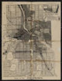
1924. Minneapolis (Minn.). City Planning Commission. Shows districts by type of use. Prime meridian: Greenwich.; Verso: Wisconsin automobile road map.; "140D" in lower right. on sheet 55 x 43 centimet... City Planning Commission (Minneapolis, Minn).
Continually updated resource. MapIT Minneapolis. For questions about this data please contactCPEDOpenData@minneapolismn.govDesignated land use features from the City's adopted comprehensive plan.
Continually updated resource. MapIT Minneapolis. Display - This is the address of the property, the permit was issued for APN - The Assessor's Parcel Number (APN) is a unique number assigned by th...
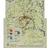
1958. Chen, Wei and Levinson, David M. High-quality GIS land use maps for the Twin Cities Metropolitan Area for 1958 that were developed from paper maps (no GIS version existed previousl...
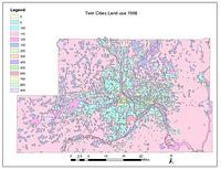
1968. Chen, Wei and Levinson, David M. High-quality GIS land use maps for the Twin Cities Metropolitan Area for 1968 that were developed from paper maps (no GIS version existed previousl...
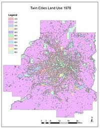
1978. Chen, Wei and Levinson, David M. High-quality GIS land use maps for the Twin Cities Metropolitan Area for 1978 that were developed from paper maps (no GIS version existed previousl...
Continually updated resource. MapIT Minneapolis. For questions about this data please contactCPEDOpenData@minneapolismn.govGoods and Services Corridors serve two purposes within the Minneapolis 20...
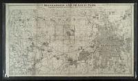
1892?. Minneapolis Land & Investment Co. (Minneapolis, Minn.). Plat information as of 1890, railroad lines as of 1892. Area shown includes western and central Hennepin Co. and the western edge of St. Paul shows...
2016. MapIT Minneapolis. For questions about this data please contact311OpenData@minneapolismn.gov The data provided are public-facing service requests that were taken by 3...
2017. MapIT Minneapolis. For questions about this data please contact311OpenData@minneapolismn.gov The data provided are public-facing service requests that were taken by 3...
2018. MapIT Minneapolis. For questions about this data please contact311OpenData@minneapolismn.gov The data provided are public-facing service requests that were taken by 3...
2019. MapIT Minneapolis. For questions about this data please contact311OpenData@minneapolismn.gov The data provided are public-facing service requests that were taken by 3...
2015. MapIT Minneapolis. For questions about this data please contact311OpenData@minneapolismn.govThe data provided are public-facing service requests that were taken by 31...
2020. MapIT Minneapolis. For questions about this data please contact311OpenData@minneapolismn.govThe data provided are public-facing service requests that were taken by 31...