1. Future Land Use and Built Form [Minnesota--Minneapolis] {2040}
2040. MapIT Minneapolis. For questions about this data please contactCPEDOpenData@minneapolismn.govThe Future Land Use and Built Form Maps are the primary tools for impleme...
2040. MapIT Minneapolis. For questions about this data please contactCPEDOpenData@minneapolismn.govThe Future Land Use and Built Form Maps are the primary tools for impleme...
![Generalized Land Use 2005 [Minnesota]](https://geo.btaa.org/rails/active_storage/representations/redirect/eyJfcmFpbHMiOnsibWVzc2FnZSI6IkJBaHBBbHFMIiwiZXhwIjpudWxsLCJwdXIiOiJibG9iX2lkIn19--c8756a9879899490adab298de6e8279f733552fc/eyJfcmFpbHMiOnsibWVzc2FnZSI6IkJBaDdCem9MWm05eWJXRjBTU0lKYW5CbFp3WTZCa1ZVT2hKeVpYTnBlbVZmZEc5ZlptbDBXd2RwQWNndyIsImV4cCI6bnVsbCwicHVyIjoidmFyaWF0aW9uIn19--fb19b03b9eb4e78013d4cfb2b84169f3537e0279/8eb314dc-9a4e-4d8c-999e-6fdcf401c663.jpeg)
2005-04-14. Metropolitan Council of the Twin Cities Area. The 2005 Generalized Land Use dataset encompasses the seven county Twin Cities (Minneapolis and St. Paul) Metropolitan Area in Minnesota. The data...
![Generalized Land Use 2016 [Minnesota]](https://geo.btaa.org/rails/active_storage/representations/redirect/eyJfcmFpbHMiOnsibWVzc2FnZSI6IkJBaHBBbHlMIiwiZXhwIjpudWxsLCJwdXIiOiJibG9iX2lkIn19--63535dcb501ef0b3153d1fe1b48b8f5cf2a86bdd/eyJfcmFpbHMiOnsibWVzc2FnZSI6IkJBaDdCem9MWm05eWJXRjBTU0lKYW5CbFp3WTZCa1ZVT2hKeVpYTnBlbVZmZEc5ZlptbDBXd2RwQWNndyIsImV4cCI6bnVsbCwicHVyIjoidmFyaWF0aW9uIn19--fb19b03b9eb4e78013d4cfb2b84169f3537e0279/249d522a-1f68-4714-8160-a8948df939f6.jpeg)
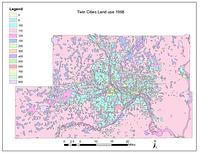
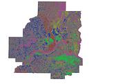
2016-04-22. Metropolitan Council of the Twin Cities Area. The 2016 Generalized Land Use Inventory dataset encompasses the seven county Twin Cities (Minneapolis and St. Paul) Metropolitan Area in Minnesota....
2020-04-10. Metropolitan Council of the Twin Cities Area. The 2020 Generalized Land Use Inventory dataset encompasses the seven county Twin Cities (Minneapolis and St. Paul) Metropolitan Area in Minnesota....
![Generalized Land Use 2000 [Minnesota]](https://geo.btaa.org/rails/active_storage/representations/redirect/eyJfcmFpbHMiOnsibWVzc2FnZSI6IkJBaHBBbG1MIiwiZXhwIjpudWxsLCJwdXIiOiJibG9iX2lkIn19--866bf99b41fee6265daf86e4e9e96ac67684969b/eyJfcmFpbHMiOnsibWVzc2FnZSI6IkJBaDdCem9MWm05eWJXRjBTU0lKYW5CbFp3WTZCa1ZVT2hKeVpYTnBlbVZmZEc5ZlptbDBXd2RwQWNndyIsImV4cCI6bnVsbCwicHVyIjoidmFyaWF0aW9uIn19--fb19b03b9eb4e78013d4cfb2b84169f3537e0279/8aac47fc-7f1a-4ab5-ac8b-3659e970c3d8.jpeg)
2000-05-01. Metropolitan Council of the Twin Cities Area. The 2000 Generalized Land Use dataset encompasses the seven county Twin Cities (Minneapolis and St. Paul) Metropolitan Area in Minnesota. The data...
![Generalized Land Use 2010 [Minnesota]](https://geo.btaa.org/rails/active_storage/representations/redirect/eyJfcmFpbHMiOnsibWVzc2FnZSI6IkJBaHBBbHVMIiwiZXhwIjpudWxsLCJwdXIiOiJibG9iX2lkIn19--dde841b25d7e88886ab0f21dcc33df1ff5701cf9/eyJfcmFpbHMiOnsibWVzc2FnZSI6IkJBaDdCem9MWm05eWJXRjBTU0lKYW5CbFp3WTZCa1ZVT2hKeVpYTnBlbVZmZEc5ZlptbDBXd2RwQWNndyIsImV4cCI6bnVsbCwicHVyIjoidmFyaWF0aW9uIn19--fb19b03b9eb4e78013d4cfb2b84169f3537e0279/5c531877-7ab8-4a03-8080-6c59440561d1.jpeg)
2010-04-20. Metropolitan Council of the Twin Cities Area. The 2010 Generalized Land Use Inventory dataset encompasses the seven county Twin Cities (Minneapolis and St. Paul) Metropolitan Area in Minnesota....
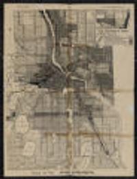
1924. Minneapolis (Minn.). City Planning Commission. Shows districts by type of use. Prime meridian: Greenwich.; Verso: Wisconsin automobile road map.; "140D" in lower right. on sheet 55 x 43 centimet... City Planning Commission (Minneapolis, Minn).
Continually updated resource. MapIT Minneapolis. For questions about this data please contactCPEDOpenData@minneapolismn.govDesignated land use features from the City's adopted comprehensive plan.
Continually updated resource. MapIT Minneapolis. Display - This is the address of the property, the permit was issued for APN - The Assessor's Parcel Number (APN) is a unique number assigned by th...
1958. Chen, Wei and Levinson, David M. High-quality GIS land use maps for the Twin Cities Metropolitan Area for 1958 that were developed from paper maps (no GIS version existed previousl...
1968. Chen, Wei and Levinson, David M. High-quality GIS land use maps for the Twin Cities Metropolitan Area for 1968 that were developed from paper maps (no GIS version existed previousl...
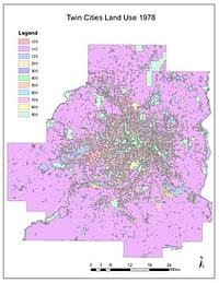
1978. Chen, Wei and Levinson, David M. High-quality GIS land use maps for the Twin Cities Metropolitan Area for 1978 that were developed from paper maps (no GIS version existed previousl...
Continually updated resource. MapIT Minneapolis. For questions about this data please contactCPEDOpenData@minneapolismn.govGoods and Services Corridors serve two purposes within the Minneapolis 20...
1892?. Minneapolis Land & Investment Co. (Minneapolis, Minn.). Plat information as of 1890, railroad lines as of 1892. Area shown includes western and central Hennepin Co. and the western edge of St. Paul shows...
2016. MapIT Minneapolis. For questions about this data please contact311OpenData@minneapolismn.gov The data provided are public-facing service requests that were taken by 3...
2017. MapIT Minneapolis. For questions about this data please contact311OpenData@minneapolismn.gov The data provided are public-facing service requests that were taken by 3...
2018. MapIT Minneapolis. For questions about this data please contact311OpenData@minneapolismn.gov The data provided are public-facing service requests that were taken by 3...
2019. MapIT Minneapolis. For questions about this data please contact311OpenData@minneapolismn.gov The data provided are public-facing service requests that were taken by 3...
2015. MapIT Minneapolis. For questions about this data please contact311OpenData@minneapolismn.govThe data provided are public-facing service requests that were taken by 31...
2020. MapIT Minneapolis. For questions about this data please contact311OpenData@minneapolismn.govThe data provided are public-facing service requests that were taken by 31...
![Generalized Land Use Historical (1984, 1990, 1997, 2000, 2005, 2010, 2016, 2020) [Minnesota]](https://geo.btaa.org/rails/active_storage/representations/redirect/eyJfcmFpbHMiOnsibWVzc2FnZSI6IkJBaHBBbGlMIiwiZXhwIjpudWxsLCJwdXIiOiJibG9iX2lkIn19--c071cbdf309246cc37e9d4f13f25352e274c33b9/eyJfcmFpbHMiOnsibWVzc2FnZSI6IkJBaDdCem9MWm05eWJXRjBTU0lKYW5CbFp3WTZCa1ZVT2hKeVpYTnBlbVZmZEc5ZlptbDBXd2RwQWNndyIsImV4cCI6bnVsbCwicHVyIjoidmFyaWF0aW9uIn19--fb19b03b9eb4e78013d4cfb2b84169f3537e0279/15a50230-0245-41ae-b6fd-fbb2ebc06ba7.jpeg)
2020-04-10. Metropolitan Council of the Twin Cities Area. The Historical Generalized Land Use dataset encompasses the seven county Twin Cities (Minneapolis and St. Paul) Metropolitan Area in Minnesota. The...
Continually updated resource. MapIT Minneapolis. Built form - this column is the name of the built form district Abbrv - this column is the abbreviation of the name of the district Built form dist...
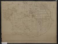
1887. Davison, C. Wright, 1849-1925. Sheets numbered 101 to 150.; Sheets 101-146 drawn by C.W. Clark; sheet 147 drawn by C.W. Clark and H.A.H. d'Ailly; sheets 148-150 drawn by H.A.H. d... C. Wright Davison (Minneapolis), 1887.
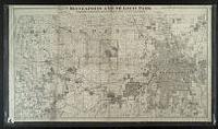
![Davisons [sic] map 25 miles around Minneapolis : 1881 corrected to 1884](https://geo.btaa.org/rails/active_storage/representations/redirect/eyJfcmFpbHMiOnsibWVzc2FnZSI6IkJBaHBBbDF5IiwiZXhwIjpudWxsLCJwdXIiOiJibG9iX2lkIn19--e2a371359b0a0b478005b350887b5a48c3690be0/eyJfcmFpbHMiOnsibWVzc2FnZSI6IkJBaDdCem9MWm05eWJXRjBTU0lKYW5CbFp3WTZCa1ZVT2hKeVpYTnBlbVZmZEc5ZlptbDBXd2RwQWNndyIsImV4cCI6bnVsbCwicHVyIjoidmFyaWF0aW9uIn19--fb19b03b9eb4e78013d4cfb2b84169f3537e0279/p16022coll245-869.jpeg)
1884. Cooley, George Washington (1845-1920). Shows metropolitan area of both Minneapolis and Saint Paul. Also shows railroad lines, roads, Public Land Survey townships and sections, cemeteries... C. Wright Davison. Lith. By Johnson, Smith & Harrison (Minneapolis, Minn.), 1881.
2008-04-23. U.S. Geological Survey (USGS). This dataset consists of 0.3-meter pixel resolution (approximately 1-foot), natural color orthoimages covering the Minneapolis-St. Paul urban area ...
U.S. Geological Survey (USGS). This dataset consists of 0.3-meter pixel resolution (approximately 1-foot), natural color orthoimages covering 1/3 of the Minneapolis-St. Paul urb...
U.S. Geological Survey (USGS) and Digital Aerial Solutions, LLC. This dataset consists of 0.3-meter pixel resolution (approximately 1-foot), natural color orthoimages covering the Minneapolis-St. Paul urban area ...
2004-04-24. National Geospatial-Intelligence Agency (NGA), U.S. Geological Survey (USGS). This dataset consists of 0.3-meter pixel resolution (approximately 1-foot), natural color orthoimages covering the Minneapolis-St. Paul urban area ...
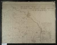
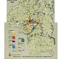
1925. Minneapolis (Minn.). City Planning Commission. Also shows railroads and the Public Land Survey grid. 149 x 102 centimeters 1:36,000 Minneapolis and St. Paul Maps and Atlases. Minneapolis (Minn.). City Planning Commission. (Minneapolis, Minn.?).
1925. Minneapolis (Minn.). City Planning Commission. Also shows railroads and the Public Land Survey grid. 149 x 102 centimeters Scale [1:36,000] 1 inch to 3000 feet Minneapolis and St. Paul Maps and ... The Commission (Minneapolis, Minn.?).
1928. McGill-Warner Co. State lands for sale in 1929 indicated in red.; In each township with a red dot, the state is offering, at public auction, various tracts of state-... McGill-Warner (St. Paul), 1928.
1925. McGill-Warner Co. State lands for sale in 1927 indicated in red.; In each township with a red dot, the state is offering, at public auction, various tracts of state-... McGill-Warner (St. Paul), 1925.
1925. McGill-Warner Co. State lands for sale in 1925 indicated in red.; In each township with a red dot, the state is offering, at public auction, various tracts of state-... McGill-Warner (St. Paul), 1925.
1925. Minnesota State Board of Immigration. Title from outside when folded.; Insets: Mesabi Range.--Cook County, northeastern Minnesota.--St. Paul-Minneapolis and vicinity.; Inset photos on v... Minnesota State Board of Immigration : (St. Paul), 1925.

1898-1904. United States. Mississippi River Commission. Survey of the Mississippi River; made under the direction of the Mississippi River Commission. Contains Charts 201-240. Each chart is at a scale of... Mississippi River Commission.
1898-1904. United States. Mississippi River Commission. Survey of the Mississippi River; made under the direction of the Mississippi River Commission. Contains Charts 241-278. Each chart is at a scale of... Mississippi River Commission.
1876-1899. United States. Mississippi River Commission. Survey of the Mississippi River; made under the direction of the Mississippi River Commission. Contains Charts 101-134. Each chart is at a scale of... Mississippi River Commission.

1876-1899. United States. Mississippi River Commission. Survey of the Mississippi River; made under the direction of the Mississippi River Commission. Contains Charts 135-148, 150, 152-165, 167-168, 170-... Mississippi River Commission.
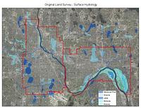
1848-1858. Graves, Richard (Professor of architecture), Kernik, Melinda, Kne, Len, Mattke, Ryan, Shepard, Coleman, and Strong, Richard (Professor of architecture). These shapefiles of lakes, streams, wetlands, river bottoms, and the Mississippi River represent the hydrological landscape of Minneapolis and St. ...
2016-07-22. Metropolitan Council of the Twin Cities Area. The Land Surface Temperature (LST) raster dataset is a dataset derived from a satellite image from Landsat 8 to show the land surface temperature f...
2022-09-01. Metropolitan Council of the Twin Cities Area. High resolution (10 meter) land surface temperature (LST) from September 1, 2022 is mapped for the seven-county metropolitan region of the Twin Cit...
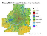
2011-2015. Host, Trevor K., Knight, Joe F., and Rampi, Lian P. A high-resolution (1-meter) land cover classification raster dataset was completed for three different geographic areas in Minnesota: Duluth, Roche... Remote Sensing and Geospatial Analysis Laboratory.
Richard Strong, Ryan Mattke, Len Kne, Coleman Shepard, Melinda Kernik, and Richard Graves, U of MN. These shapefiles of lakes, streams, wetlands, river bottoms, and the Mississippi River represent the hydrological landscape of Minneapolis and St. ...
1968. Dan Milz, Jacobs, Paul (Research assistant), Kne, Len, Rebecca Barney, and Ya Tao. A digitized version of Ian McHarg's original 1968 Ecological Study for the Twin Cities Metropolitan Area: Composite Intrinsic Suitability. These ma... U-Spatial.
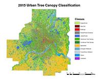
2015. Host, Trevor K., Knight, Joe F., and Rampi, Lian P. A high-resolution (1-meter) tree canopy assessment was completed for the Twin Cities Metropolitan Area. Mapping of existing and potential tree cano...
![Davisons [sic] map 25 miles around the Twin Cities : 1881 corrected to 1889](https://geo.btaa.org/rails/active_storage/representations/redirect/eyJfcmFpbHMiOnsibWVzc2FnZSI6IkJBaHBBbDV5IiwiZXhwIjpudWxsLCJwdXIiOiJibG9iX2lkIn19--1cfa66af7e0468ba51cd76e61726920357368cc6/eyJfcmFpbHMiOnsibWVzc2FnZSI6IkJBaDdCem9MWm05eWJXRjBTU0lKYW5CbFp3WTZCa1ZVT2hKeVpYTnBlbVZmZEc5ZlptbDBXd2RwQWNndyIsImV4cCI6bnVsbCwicHVyIjoidmFyaWF0aW9uIn19--fb19b03b9eb4e78013d4cfb2b84169f3537e0279/p16022coll245-896.jpeg)
1889. Cooley, George Washington (1845-1920). Also shows railroad lines, roads, Public Land Survey townships and sections, cemeteries, churches, and schools. Entered according to act of Congres... C. Wright Davison, Minneapolis Directory Co (Minneapolis, Minn.?), 1881.
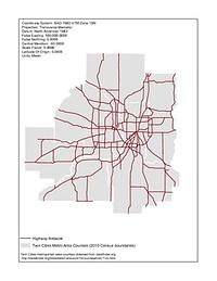
1920-1995. Chen, Wei and Levinson, David M. Illustrates the development of the highway network in the Twin Cities metropolitan region. GIS maps of the state highway network were created for 1...
approximately 1912. 19 x 26 centimeters Minneapolis and St. Paul Maps and Atlases. [publisher not identified], (Minn.?).
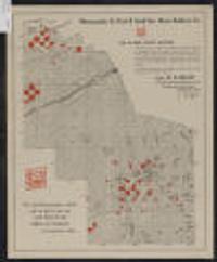
1910-1919?. Minneapolis, St. Paul & Sault Ste. Marie Railway Company. Shows land for sale by the Soo Line, town sections, schools, churches, and farms.; "For particular information ... address W.H. Killen, land and in... Minneapolis, St. Paul & Sault Ste. Marie Railway Co (Minneapolis, Minn).
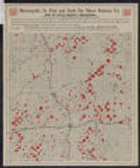
1910-1919?. Minneapolis, St. Paul & Sault Ste. Marie Railway Company. Shows land owned and for sale by the Soo Line (Wisconsin Central Ry. Land Grant lands). Also shows schools, churches, and farms.; "W.H. Killen, lan... Soo Line (Minneapolis, Minn.?).